- About project
- Collections
- Indexes
- Recently viewed
-
RCIN Repositories
-
 INSTYTUT ARCHEOLOGII I ETNOLOGII POLSKIEJ AKADEMII NAUK
-
 INSTYTUT BADAŃ LITERACKICH POLSKIEJ AKADEMII NAUK
-
 INSTYTUT BADAWCZY LEŚNICTWA
-
 INSTYTUT BIOLOGII DOŚWIADCZALNEJ IM. MARCELEGO NENCKIEGO POLSKIEJ AKADEMII NAUK
-
 INSTYTUT BIOLOGII SSAKÓW POLSKIEJ AKADEMII NAUK
-
 INSTYTUT CHEMII FIZYCZNEJ PAN
-
 INSTYTUT CHEMII ORGANICZNEJ PAN
-
 INSTYTUT FILOZOFII I SOCJOLOGII PAN
-
 INSTYTUT GEOGRAFII I PRZESTRZENNEGO ZAGOSPODAROWANIA PAN
-
 INSTYTUT HISTORII im. TADEUSZA MANTEUFFLA POLSKIEJ AKADEMII NAUK
-
 INSTYTUT JĘZYKA POLSKIEGO POLSKIEJ AKADEMII NAUK
-
 INSTYTUT MATEMATYCZNY PAN
-
 INSTYTUT MEDYCYNY DOŚWIADCZALNEJ I KLINICZNEJ IM.MIROSŁAWA MOSSAKOWSKIEGO POLSKIEJ AKADEMII NAUK
-
 INSTYTUT PODSTAWOWYCH PROBLEMÓW TECHNIKI PAN
-
 INSTYTUT SLAWISTYKI PAN
-
 SIEĆ BADAWCZA ŁUKASIEWICZ - INSTYTUT TECHNOLOGII MATERIAŁÓW ELEKTRONICZNYCH
-
 MUZEUM I INSTYTUT ZOOLOGII POLSKIEJ AKADEMII NAUK
-
 INSTYTUT BADAŃ SYSTEMOWYCH PAN
-
 INSTYTUT BOTANIKI IM. WŁADYSŁAWA SZAFERA POLSKIEJ AKADEMII NAUK
-

Object
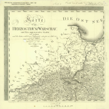
Title: Karte vom Herzogthum Warschau und den angrenzenden Staaten in IV Sectionen ; Mapa Księstwa Warszawskiego F. B. Engelhardta z roku 1810 powiększona do podziałki 1:600 000 ; Carte du Duché de Varsovie et des Etats qui l'environnent
Creator:
Engelhardt, Friedrich Bernhard (1768–1854) ; Schmidt, Paulus : Ryt. ; Maré, Carl (fl. 1804-1845) : Ryt.
Date issued/created:
Resource type:
Publisher:
Place of publishing:
Description:
Scale 1:600 000 ; 1 map on 4 sheets ; each sheet 58x61 cm, total 116x122 cm ; Reproduction from the map published by Simon Schropp & Comp. in Berlin and Ch. Picquet in Paris 1812 ; Date of publication from BNPol online ; Prime meridian Ferro ; Title in French, Polish and German, legend of signs in German
Detailed Resource Type:
Format:
File size 22,9 MB ; application/pdf
Resource Identifier:
Source:
CBGiOŚ. IGiPZ PAN, call no. D.7776 [IX.4-h.2] ; click here to follow the link
Language:
Rights:
Terms of use:
Digitizing institution:
Institute of Geography and Spatial Organization of the Polish Academy of Sciences
Original in:
Projects co-financed by:
Programme Innovative Economy, 2010-2014, Priority Axis 2. R&D infrastructure ; European Union. European Regional Development Fund
Access:
Object collections:
- Institute of Geography and Spatial Organization PAS (IGiPZ PAN) > Library
- Institute of Geography and Spatial Organization PAS (IGiPZ PAN) > Library > Maps and atlases
Last modified:
Oct 2, 2020
In our library since:
Feb 22, 2018
Number of object content downloads / hits:
1468
All available object's versions:
https://rcin.org.pl/igipz/publication/14379
Show description in RDF format:
Show description in RDFa format:
Show description in OAI-PMH format:
Objects Similar
Karte von dem Königreich Pohlen, Gross-Herzogthum Posen und den angrenzenden Staaten in IV Sectionen
Engelhardt, Friedrich Bernhard (1768–1854) Maré, Carl (fl. 1804-1845) Schmidt, Paulus
Engelhardt, Friedrich Bernhard (1768–1854)
Engelhardt, Friedrich Bernhard (1768–1854)
Künzel-Pougenmül. Rys.
Liechtenstern, Joseph Marx von (1765–1828) Hartl, Martin (18..-19..). Rys.
Rizzi-Zannoni, Giovanni Antonio (c. 1736 – 1814)
Textor, Johann Christoph von ( –1812)
Textor, Johann Christoph von ( –1812)


