- About project
- Collections
- Indexes
- Recently viewed
-
RCIN Repositories
-
 INSTYTUT ARCHEOLOGII I ETNOLOGII POLSKIEJ AKADEMII NAUK
-
 INSTYTUT BADAŃ LITERACKICH POLSKIEJ AKADEMII NAUK
-
 INSTYTUT BADAWCZY LEŚNICTWA
-
 INSTYTUT BIOLOGII DOŚWIADCZALNEJ IM. MARCELEGO NENCKIEGO POLSKIEJ AKADEMII NAUK
-
 INSTYTUT BIOLOGII SSAKÓW POLSKIEJ AKADEMII NAUK
-
 INSTYTUT CHEMII FIZYCZNEJ PAN
-
 INSTYTUT CHEMII ORGANICZNEJ PAN
-
 INSTYTUT FILOZOFII I SOCJOLOGII PAN
-
 INSTYTUT GEOGRAFII I PRZESTRZENNEGO ZAGOSPODAROWANIA PAN
-
 INSTYTUT HISTORII im. TADEUSZA MANTEUFFLA POLSKIEJ AKADEMII NAUK
-
 INSTYTUT JĘZYKA POLSKIEGO POLSKIEJ AKADEMII NAUK
-
 INSTYTUT MATEMATYCZNY PAN
-
 INSTYTUT MEDYCYNY DOŚWIADCZALNEJ I KLINICZNEJ IM.MIROSŁAWA MOSSAKOWSKIEGO POLSKIEJ AKADEMII NAUK
-
 INSTYTUT PODSTAWOWYCH PROBLEMÓW TECHNIKI PAN
-
 INSTYTUT SLAWISTYKI PAN
-
 SIEĆ BADAWCZA ŁUKASIEWICZ - INSTYTUT TECHNOLOGII MATERIAŁÓW ELEKTRONICZNYCH
-
 MUZEUM I INSTYTUT ZOOLOGII POLSKIEJ AKADEMII NAUK
-
 INSTYTUT BADAŃ SYSTEMOWYCH PAN
-
 INSTYTUT BOTANIKI IM. WŁADYSŁAWA SZAFERA POLSKIEJ AKADEMII NAUK
-

Object
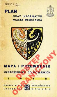
Title: Plan oraz informator miasta Wrocławia : mapa i przewodnik po uzdrowiskach dolnośląskich
Creator:
Korytko, Stefan : Kartogr. ; Maleczyński, Karol (1897–1968) : Tekst ; Grotowski, Zbigniew : Tekst ; Potocki, Ignacy (1906–1994) : Tekst
Date issued/created:
Resource type:
Subtitle:
Mapa i przewodnik po uzdrowiskach dolnośląskich
Publisher:
Nakładem Spółdzielni Wydawniczo-Oświatowej "Czytelnik" Delegatura Śląska
Place of publishing:
Description:
Scales differ ; 5 maps on 3 sheets : on sheet 38x29 cm, 45x36 cm, 42x22 cm, folded 18x11 cm + guide: 60 pp. ; 19 cm. ; Sheet 1: Wrocław [scale ca 1:24 000]. Aut. S. Korytko ; Sheet 2: Śródmieście [scale ca 1:7 100] ; Sheet 3: [Dolny Śląsk scale ca 1:700 000], Turystyczna mapa Karkonoszy [scale ca 1:210 000], Wrocław [scale ca 1:139 000] ; Title from the cover ; Includes: Z dziejów Wrocławia ; Wystawa Ziem Odzyskanych dzieło sztuki i techniki ; Alfabetyczny spis ulic ; Skorowidz [instytucji] ; Komunikacja ; Zabytki ; Dolny Śląsk - kraina uzdrowisk ; Skorowidz uzdrowisk dolnośląskich ; Stacje klimatyczne ; Chapters' authors: Karol Maleczyński, Zbigniew Grotowski, Ignacy Potocki ; Index of streets
Detailed Resource Type:
Format:
File size 5,5 MB ; image/x.djvu
Resource Identifier:
Source:
CBGiOŚ. IGiPZ PAN, call no. D.21335 ; click here to follow the link
Language:
Rights:
Rights Reserved - Restricted Access
Terms of use:
Digitizing institution:
Institute of Geography and Spatial Organization of the Polish Academy of Sciences
Original in:
Projects co-financed by:
Programme Innovative Economy, 2010-2014, Priority Axis 2. R&D infrastructure ; European Union. European Regional Development Fund
Access:
Object collections:
- Digital Repository of Scientific Institutes > Partners' collections > Institute of Geography and Spatial Organization PAS (IGiPZ PAN) > Library
- Digital Repository of Scientific Institutes > Partners' collections > Institute of Geography and Spatial Organization PAS (IGiPZ PAN) > Library > Maps and atlases
- Digital Repository of Scientific Institutes > Literature > Maps/Atlases
Last modified:
Jun 15, 2021
In our library since:
Sep 11, 2012
Number of object content downloads / hits:
63
All available object's versions:
https://rcin.org.pl/publication/22055
Show description in RDF format:
Show description in RDFa format:
Show description in OAI-PMH format:
| Edition name | Date |
|---|---|
| Plan oraz informator miasta Wrocławia : mapa i przewodnik po uzdrowiskach dolnośląskich, 1948 | Jun 15, 2021 |
Objects Similar
Wydawnictwo Przełom. Wydawca
Województwo Wrocławskie (Polska). Urząd Wojewódzki. Wydział Pomiarów. Wykonawca


