- About project
- Collections
- Indexes
- Recently viewed
-
RCIN Repositories
-
 INSTYTUT ARCHEOLOGII I ETNOLOGII POLSKIEJ AKADEMII NAUK
-
 INSTYTUT BADAŃ LITERACKICH POLSKIEJ AKADEMII NAUK
-
 INSTYTUT BADAWCZY LEŚNICTWA
-
 INSTYTUT BIOLOGII DOŚWIADCZALNEJ IM. MARCELEGO NENCKIEGO POLSKIEJ AKADEMII NAUK
-
 INSTYTUT BIOLOGII SSAKÓW POLSKIEJ AKADEMII NAUK
-
 INSTYTUT CHEMII FIZYCZNEJ PAN
-
 INSTYTUT CHEMII ORGANICZNEJ PAN
-
 INSTYTUT FILOZOFII I SOCJOLOGII PAN
-
 INSTYTUT GEOGRAFII I PRZESTRZENNEGO ZAGOSPODAROWANIA PAN
-
 INSTYTUT HISTORII im. TADEUSZA MANTEUFFLA POLSKIEJ AKADEMII NAUK
-
 INSTYTUT JĘZYKA POLSKIEGO POLSKIEJ AKADEMII NAUK
-
 INSTYTUT MATEMATYCZNY PAN
-
 INSTYTUT MEDYCYNY DOŚWIADCZALNEJ I KLINICZNEJ IM.MIROSŁAWA MOSSAKOWSKIEGO POLSKIEJ AKADEMII NAUK
-
 INSTYTUT PODSTAWOWYCH PROBLEMÓW TECHNIKI PAN
-
 INSTYTUT SLAWISTYKI PAN
-
 SIEĆ BADAWCZA ŁUKASIEWICZ - INSTYTUT TECHNOLOGII MATERIAŁÓW ELEKTRONICZNYCH
-
 MUZEUM I INSTYTUT ZOOLOGII POLSKIEJ AKADEMII NAUK
-
 INSTYTUT BADAŃ SYSTEMOWYCH PAN
-
 INSTYTUT BOTANIKI IM. WŁADYSŁAWA SZAFERA POLSKIEJ AKADEMII NAUK
-

Object
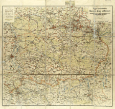
Title: Paul Raschdorff's Übersichts-, Gruben- und Hüttenkarte des oberschlesischen (preuss.) mährisch-ostrau-karwiner (österreich.) und russisch-polnischen Industriebezirks (Dreikaiserecke)
Contributor:
Publisher:
Place of publishing:
Description:
Skala 1:125 000 ; 1 mapa : litogr. kolor. ; na ark. 70x73 cm ; Tyt. z mapy w prawym górnym rogu ; Na mapie naniesiona siatka skorowidzowa ; Mapa ukazywała się także z tekstem objaśniającym: Beiheft zu Paul Raschdorff's Handkarte des oberschlesischen (preuss.), österreich.-schlesischen und russisch-polnischen Industriebezirks / Paul Raschdorff. - Kolberg, [ca 1899] ; W prawym dolnym rogu mapa poboczna: Übersichtsplan zur Hauptkarte w skali 1:2 750 000. W lewym górnym rogu legenda ; Pod dolną ramką: Lith. Osw. Melching, Leipzig ; Druck: Gebr. Lissel, Liepzig ; Data wyd. wg Historia nowożytnej kartografii Śląska 1800-1939 / Henryk Kot. - Katowice, 1970 poz. 232, s. 175 ; BNPol online
Detailed Resource Type:
Format:
File size 9,2 MB ; application/pdf
Resource Identifier:
Source:
CBGiOŚ. IGiPZ PAN, call no. D.11581 [II.7B-29] ; click here to follow the link
Language:
Rights:
Terms of use:
Digitizing institution:
Institute of Geography and Spatial Organization of the Polish Academy of Sciences
Original in:
Projects co-financed by:
Programme Innovative Economy, 2010-2014, Priority Axis 2. R&D infrastructure ; European Union. European Regional Development Fund
Access:
Object collections:
- Digital Repository of Scientific Institutes > Partners' collections > Institute of Geography and Spatial Organization PAS (IGiPZ PAN) > Library
- Digital Repository of Scientific Institutes > Partners' collections > Institute of Geography and Spatial Organization PAS (IGiPZ PAN) > Library > Maps and atlases
- Digital Repository of Scientific Institutes > Literature > Maps/Atlases
Last modified:
Oct 2, 2020
In our library since:
May 22, 2017
Number of object content downloads / hits:
719
All available object's versions:
https://rcin.org.pl/publication/52482
Show description in RDF format:
Show description in RDFa format:
Show description in OAI-PMH format:
Objects Similar
Samborska-Kukuć, Dorota Jaros, Maja Giebułtowski, Jerzy
Egloff, Jerzy
Osiecki, Jan (1827–1901)
Osiecki, Jan (1827–1901)
Handtke, Friedrich H. (1815–1879) Carl Flemming und C. T. Wiskott Aktiengesellschaft für Verlag und Kunstdruck (Głogów)


