- About project
- Collections
- Indexes
- Recently viewed
-
RCIN Repositories
-
 INSTYTUT ARCHEOLOGII I ETNOLOGII POLSKIEJ AKADEMII NAUK
-
 INSTYTUT BADAŃ LITERACKICH POLSKIEJ AKADEMII NAUK
-
 INSTYTUT BADAWCZY LEŚNICTWA
-
 INSTYTUT BIOLOGII DOŚWIADCZALNEJ IM. MARCELEGO NENCKIEGO POLSKIEJ AKADEMII NAUK
-
 INSTYTUT BIOLOGII SSAKÓW POLSKIEJ AKADEMII NAUK
-
 INSTYTUT CHEMII FIZYCZNEJ PAN
-
 INSTYTUT CHEMII ORGANICZNEJ PAN
-
 INSTYTUT FILOZOFII I SOCJOLOGII PAN
-
 INSTYTUT GEOGRAFII I PRZESTRZENNEGO ZAGOSPODAROWANIA PAN
-
 INSTYTUT HISTORII im. TADEUSZA MANTEUFFLA POLSKIEJ AKADEMII NAUK
-
 INSTYTUT JĘZYKA POLSKIEGO POLSKIEJ AKADEMII NAUK
-
 INSTYTUT MATEMATYCZNY PAN
-
 INSTYTUT MEDYCYNY DOŚWIADCZALNEJ I KLINICZNEJ IM.MIROSŁAWA MOSSAKOWSKIEGO POLSKIEJ AKADEMII NAUK
-
 INSTYTUT PODSTAWOWYCH PROBLEMÓW TECHNIKI PAN
-
 INSTYTUT SLAWISTYKI PAN
-
 SIEĆ BADAWCZA ŁUKASIEWICZ - INSTYTUT TECHNOLOGII MATERIAŁÓW ELEKTRONICZNYCH
-
 MUZEUM I INSTYTUT ZOOLOGII POLSKIEJ AKADEMII NAUK
-
 INSTYTUT BADAŃ SYSTEMOWYCH PAN
-
 INSTYTUT BOTANIKI IM. WŁADYSŁAWA SZAFERA POLSKIEJ AKADEMII NAUK
-

Object
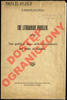
Title: The Lithuanian problem : Two political maps with observations and tables of statistics
Subtitle:
Political position on the coast of the Baltic sea in the case of Partition of Lithuania followed by the incorporation of the Polish part of Lithuanian lands to Poland 1:4 000 000 ; Political position on the coast of the Baltic sea in the case of the federation Lithuania with Poland 1:4 000 000
Contributor:
Publisher:
Issued by the Provisory Political Commitee of the Kowno lands ; (Zakł. Kart. W. Główczewski)
Place of publishing:
Description:
Skala 1:4 000 000 ; 2 mapy na 1 ark. : kolor. każda 31x32 cm, na ark. 34x86 cm, po złoż. w okł. 34x22 cm ; Tyt. z okł ; Brak prezentacji rzeźby ; Na ark, z lewej strony tekst: Remakrs, Statistics ; Cyt. w: BNPol online ; Tekst., tyt. i legenda w jęz. ang., treść mapy w jęz. pol.
Detailed Resource Type:
Format:
Resource Identifier:
Source:
CBGiOŚ. IGiPZ PAN, call no. D.11257 [m.polit.-adm.8] ; CBGiOŚ. IGiPZ PAN, call no. D.11576 [m.polit.-adm.86] ; click here to follow the link
Language:
Rights:
Rights Reserved - Restricted Access
Terms of use:
Digitizing institution:
Institute of Geography and Spatial Organization of the Polish Academy of Sciences
Original in:
Projects co-financed by:
Programme Innovative Economy, 2010-2014, Priority Axis 2. R&D infrastructure ; European Union. European Regional Development Fund
Access:
Object collections:
- Digital Repository of Scientific Institutes > Partners' collections > Institute of Geography and Spatial Organization PAS (IGiPZ PAN) > Library
- Digital Repository of Scientific Institutes > Partners' collections > Institute of Geography and Spatial Organization PAS (IGiPZ PAN) > Library > Maps and atlases
- Digital Repository of Scientific Institutes > Literature > Maps/Atlases
Last modified:
Oct 2, 2020
In our library since:
Feb 14, 2013
Number of object content downloads / hits:
39
All available object's versions:
https://rcin.org.pl/publication/37780
Show description in RDF format:
Show description in RDFa format:
Show description in OAI-PMH format:
Objects Similar
Świechowski, Marian (1882–1934)
Świechowski, Marian (1882–1934)
Świechowski, Marian (1882–1934)
Świechowski, Marian (1882–1934)
Szturm de Sztrem, Tadeusz (1892–1968)
Machlejd, Jerzy (1909–1940)


