- About project
- Collections
- Indexes
- Recently viewed
-
RCIN Repositories
-
 INSTYTUT ARCHEOLOGII I ETNOLOGII POLSKIEJ AKADEMII NAUK
-
 INSTYTUT BADAŃ LITERACKICH POLSKIEJ AKADEMII NAUK
-
 INSTYTUT BADAWCZY LEŚNICTWA
-
 INSTYTUT BIOLOGII DOŚWIADCZALNEJ IM. MARCELEGO NENCKIEGO POLSKIEJ AKADEMII NAUK
-
 INSTYTUT BIOLOGII SSAKÓW POLSKIEJ AKADEMII NAUK
-
 INSTYTUT CHEMII FIZYCZNEJ PAN
-
 INSTYTUT CHEMII ORGANICZNEJ PAN
-
 INSTYTUT FILOZOFII I SOCJOLOGII PAN
-
 INSTYTUT GEOGRAFII I PRZESTRZENNEGO ZAGOSPODAROWANIA PAN
-
 INSTYTUT HISTORII im. TADEUSZA MANTEUFFLA POLSKIEJ AKADEMII NAUK
-
 INSTYTUT JĘZYKA POLSKIEGO POLSKIEJ AKADEMII NAUK
-
 INSTYTUT MATEMATYCZNY PAN
-
 INSTYTUT MEDYCYNY DOŚWIADCZALNEJ I KLINICZNEJ IM.MIROSŁAWA MOSSAKOWSKIEGO POLSKIEJ AKADEMII NAUK
-
 INSTYTUT PODSTAWOWYCH PROBLEMÓW TECHNIKI PAN
-
 INSTYTUT SLAWISTYKI PAN
-
 SIEĆ BADAWCZA ŁUKASIEWICZ - INSTYTUT TECHNOLOGII MATERIAŁÓW ELEKTRONICZNYCH
-
 MUZEUM I INSTYTUT ZOOLOGII POLSKIEJ AKADEMII NAUK
-
 INSTYTUT BADAŃ SYSTEMOWYCH PAN
-
 INSTYTUT BOTANIKI IM. WŁADYSŁAWA SZAFERA POLSKIEJ AKADEMII NAUK
-
- Search in all Repository
- Literature and maps
- Archeology
- Mills database
- Natural sciences
Advanced search
Advanced search
Advanced search
Advanced search
Advanced search

Object
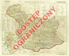
Title: Mapa województwa krakowskiego z doby Sejmu Czteroletniego (1788-1792)
Subtitle:
Atlas Historyczny Polski / Polska Akademja Umiejętności. Serja A, Mapy szczegółowe ; nr 1 ; Mapa województwa krakowskiego w dobie Sejmu Czteroletniego 1788-1792
Contributor:
Semkowicz, Władysław Aleksander (1878–1949) : Oprac. ; Buczek, Karol (1902–1983) : Oprac. ; Kozłowska-Budkowa, Zofia (1893–1986) : Oprac. ; Czort, Tadeusz : Oprac ; Wojskowy Instytut Geograficzny
Publisher:
nakł. Polskiej Akademji Umiejętności
Place of publishing:
Description:
Scale 1:200 000 ; 1 map : col. ; 65x83 cm, on sheet 75x95 cm, folded in cover 50x39 cm ; Cover title ; Subtitle: w dodatku Plan miasta Krakowa z lat 1788-1792 / oprac. Tadeusz Czort ; (osobno wydaje się tekst źródłowo-metodyczny do mapy) ; Date on the map: 1929 ; Ancillary map: Plan miasta Krakowa i okolic w dobie Sejmu Czteroletniego : podziałka 1:10.800
Relation:
Prace Komisji Atlasu Historycznego Polski ; Atlas historyczny Polski. Seria A, Mapy szczegółowe
Detailed Resource Type:
Format:
Resource Identifier:
Source:
CBGiOŚ. IGiPZ PAN, call no. B.1607 [1] ; CBGiOŚ. IGiPZ PAN, call no. D.6514 [hist.50] ; CBGiOŚ. IGiPZ PAN, call no. PTG D.657 [ hist.51] ; click here to follow the link
Language:
Rights:
Rights Reserved - Restricted Access
Terms of use:
Digitizing institution:
Institute of Geography and Spatial Organization of the Polish Academy of Sciences
Original in:
Projects co-financed by:
Programme Innovative Economy, 2010-2014, Priority Axis 2. R&D infrastructure ; European Union. European Regional Development Fund
Access:
Object collections:
- Digital Repository of Scientific Institutes > Partners' collections > Institute of Geography and Spatial Organization PAS (IGiPZ PAN) > Library
- Digital Repository of Scientific Institutes > Partners' collections > Institute of Geography and Spatial Organization PAS (IGiPZ PAN) > Library > Maps and atlases
- Digital Repository of Scientific Institutes > Partners' collections > Institute of Geography and Spatial Organization PAS (IGiPZ PAN) > Library > Selected collections > Polish Geographical Society Collection
- Digital Repository of Scientific Institutes > Literature > Maps/Atlases
Last modified:
Oct 2, 2020
In our library since:
Aug 5, 2013
Number of object content downloads / hits:
186
All available object's versions:
https://rcin.org.pl/publication/49757
Show description in RDF format:
Show description in RDFa format:
Show description in OAI-PMH format:
Objects Similar
Semkowicz, Władysław Aleksander (1878–1949)
Żebrawski, Teofil (1800–1887) Kliewer, Heinrich
Bończa-Tomaszewski, Stanisław (1861–1935)


