- O repozytorium
- Kolekcje
- Indeksy
- Historia przeglądania
-
Repozytoria RCIN
-
 INSTYTUT ARCHEOLOGII I ETNOLOGII POLSKIEJ AKADEMII NAUK
-
 INSTYTUT BADAŃ LITERACKICH POLSKIEJ AKADEMII NAUK
-
 INSTYTUT BADAWCZY LEŚNICTWA
-
 INSTYTUT BIOLOGII DOŚWIADCZALNEJ IM. MARCELEGO NENCKIEGO POLSKIEJ AKADEMII NAUK
-
 INSTYTUT BIOLOGII SSAKÓW POLSKIEJ AKADEMII NAUK
-
 INSTYTUT CHEMII FIZYCZNEJ PAN
-
 INSTYTUT CHEMII ORGANICZNEJ PAN
-
 INSTYTUT FILOZOFII I SOCJOLOGII PAN
-
 INSTYTUT GEOGRAFII I PRZESTRZENNEGO ZAGOSPODAROWANIA PAN
-
 INSTYTUT HISTORII im. TADEUSZA MANTEUFFLA POLSKIEJ AKADEMII NAUK
-
 INSTYTUT JĘZYKA POLSKIEGO POLSKIEJ AKADEMII NAUK
-
 INSTYTUT MATEMATYCZNY PAN
-
 INSTYTUT MEDYCYNY DOŚWIADCZALNEJ I KLINICZNEJ IM.MIROSŁAWA MOSSAKOWSKIEGO POLSKIEJ AKADEMII NAUK
-
 INSTYTUT PODSTAWOWYCH PROBLEMÓW TECHNIKI PAN
-
 INSTYTUT SLAWISTYKI PAN
-
 SIEĆ BADAWCZA ŁUKASIEWICZ - INSTYTUT TECHNOLOGII MATERIAŁÓW ELEKTRONICZNYCH
-
 MUZEUM I INSTYTUT ZOOLOGII POLSKIEJ AKADEMII NAUK
-
 INSTYTUT BADAŃ SYSTEMOWYCH PAN
-
 INSTYTUT BOTANIKI IM. WŁADYSŁAWA SZAFERA POLSKIEJ AKADEMII NAUK
-

Obiekt
Dostępne formaty:
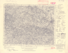
Pobierz wszystkieTytuł: Karte des Deutschen Reiches 1:100 000, 445. Zittau
Inny tytuł:
Karte des Deutschen Reiches 1:100 000 ; 445
Wydawca:
Miejsce wydania:
Opis:
Redaktionelle Änderungen 11.40 ; Skala 1:100 000 ; 1 mapa ; 30x37 cm ; Detailed legend on the right margin ; Designated kilometer grid ; Geographical coordinates only in the corners of the map ; Longitude given in Greenwich layout ; In the lower margin, numerical and designated scale and linear scale in meters, kilometers and steps ; On the bottom margin administrative division ; On the bottom margin: "Die vorwärtsliegenden Zahlen geben die Höhen über Normal-Null in Metern an" ; Release Date. 1: 1931
Typ obiektu:
Czasopismo/Seria/cykl:
Karte des Deutschen Reiches 1:100 000
Szczegółowy typ zasobu:
Format:
Identyfikator zasobu:
Źródło:
CBGiOŚ. IGiPZ PAN, call no. C.187/368 ; kliknij tutaj, żeby przejść
Język:
Zakres:
Prawa:
Zasady wykorzystania:
Digitalizacja:
Institute of Geography and Spatial Organization of the Polish Academy of Sciences
Lokalizacja oryginału:
Dofinansowane ze środków:
Dostęp:
Kolekcje, do których przypisany jest obiekt:
- Instytut Geografii i Przestrzennego Zagospodarowania PAN > Biblioteka Instytutu
- Instytut Geografii i Przestrzennego Zagospodarowania PAN > Biblioteka Instytutu > Mapy i atlasy
Data ostatniej modyfikacji:
2 paź 2020
Data dodania obiektu:
20 gru 2019
Liczba pobrań / odtworzeń:
79
Wszystkie dostępne wersje tego obiektu:
https://rcin.org.pl/igipz/publication/102572
Wyświetl opis w formacie RDF:
Wyświetl opis w formacie RDFa:
Wyświetl opis w formacie OAI-PMH:
| Nazwa wydania | Data |
|---|---|
| 445. Zittau, 1940 | 2 paź 2020 |
Obiekty Podobne
Niemcy. Reichsamt für Landesaufnahme. Redaktor Wydawca
Niemcy. Reichsamt für Landesaufnahme. Redaktor Wydawca
Niemcy. Reichsamt für Landesaufnahme. Redaktor Wydawca
Niemcy. Reichsamt für Landesaufnahme. Redaktor. Wydawca
Niemcy. Reichsamt für Landesaufnahme. Redaktor Wydawca
Niemcy. Reichsamt für Landesaufnahme. Redaktor Wydawca
Niemcy. Reichsamt für Landesaufnahme. Redaktor Wydawca
Niemcy. Reichsamt für Landesaufnahme. Redaktor Wydawca Niemcy. Reichsamt für Landesaufnahme. Zweigstelle Landesaufnahme Sachsen. Redaktor


