- About project
- Collections
- Indexes
- Recently viewed
-
RCIN Repositories
-
 INSTYTUT ARCHEOLOGII I ETNOLOGII POLSKIEJ AKADEMII NAUK
-
 INSTYTUT BADAŃ LITERACKICH POLSKIEJ AKADEMII NAUK
-
 INSTYTUT BADAWCZY LEŚNICTWA
-
 INSTYTUT BIOLOGII DOŚWIADCZALNEJ IM. MARCELEGO NENCKIEGO POLSKIEJ AKADEMII NAUK
-
 INSTYTUT BIOLOGII SSAKÓW POLSKIEJ AKADEMII NAUK
-
 INSTYTUT CHEMII FIZYCZNEJ PAN
-
 INSTYTUT CHEMII ORGANICZNEJ PAN
-
 INSTYTUT FILOZOFII I SOCJOLOGII PAN
-
 INSTYTUT GEOGRAFII I PRZESTRZENNEGO ZAGOSPODAROWANIA PAN
-
 INSTYTUT HISTORII im. TADEUSZA MANTEUFFLA POLSKIEJ AKADEMII NAUK
-
 INSTYTUT JĘZYKA POLSKIEGO POLSKIEJ AKADEMII NAUK
-
 INSTYTUT MATEMATYCZNY PAN
-
 INSTYTUT MEDYCYNY DOŚWIADCZALNEJ I KLINICZNEJ IM.MIROSŁAWA MOSSAKOWSKIEGO POLSKIEJ AKADEMII NAUK
-
 INSTYTUT PODSTAWOWYCH PROBLEMÓW TECHNIKI PAN
-
 INSTYTUT SLAWISTYKI PAN
-
 SIEĆ BADAWCZA ŁUKASIEWICZ - INSTYTUT TECHNOLOGII MATERIAŁÓW ELEKTRONICZNYCH
-
 MUZEUM I INSTYTUT ZOOLOGII POLSKIEJ AKADEMII NAUK
-
 INSTYTUT BADAŃ SYSTEMOWYCH PAN
-
 INSTYTUT BOTANIKI IM. WŁADYSŁAWA SZAFERA POLSKIEJ AKADEMII NAUK
-

Object
Available formats:
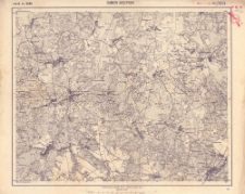
Download allTitle: Kamien Koszyrski : Zone B. Kol. XXXII
Creator:
Kaiserlich-Königliches Militär-Geographisches Institut (Wiedeń). Instytucja sprawcza. Wydawca
Date issued/created:
Resource type:
Subtitle:
Zone B. Kol. XXXII : Kamien Koszyrski ; Spezialkarte der österreichisch-ungarischen Monarchie 1:75.000. Kamien Koszyrski : Zone B. Kol. XXXII
Publisher:
Place of publishing:
Description:
Skala 1:75 000 ; 1 mapa : kolorowa ; 39 x 49 cm, na arkuszu 44 x 55 cm ; Długość geograficzna liczona na wschód od Ferro
Relation:
Spezialkarte der österreichisch-ungarischen Monarchie 1:75.000
Detailed Resource Type:
Resource Identifier:
Source:
CBGiOŚ. IGiPZ PAN, sygn. C.583/45 ; click here to follow the link
Language:
Coverage:
Rights:
Terms of use:
Digitizing institution:
Instytut Geografii i Przestrzennego Zagospodarowania Polskiej Akademii Nauk
Original in:
Projects co-financed by:
Access:
Object collections:
- Institute of Geography and Spatial Organization PAS (IGiPZ PAN) > Library
- Institute of Geography and Spatial Organization PAS (IGiPZ PAN) > Library > Maps and atlases
Last modified:
May 12, 2021
In our library since:
Dec 21, 2020
Number of object content downloads / hits:
54
All available object's versions:
https://rcin.org.pl/igipz/publication/157774
Show description in RDF format:
Show description in RDFa format:
Show description in OAI-PMH format:
| Edition name | Date |
|---|---|
| Zone B. Kol. XXXII Kamien Koszyrski, [około 1914] | May 12, 2021 |
Objects Similar
Kaiserlich-Königliches Militär-Geographisches Institut (Wiedeń). Instytucja sprawcza. Wydawca
Kaiserlich-Königliches Militär-Geographisches Institut (Wiedeń). Instytucja sprawcza. Wydawca
Kaiserlich-Königliches Militär-Geographisches Institut (Wiedeń). Instytucja sprawcza. Wydawca
Kaiserlich-Königliches Militär-Geographisches Institut (Wiedeń). Instytucja sprawcza. Wydawca
Kaiserlich-Königliches Militär-Geographisches Institut (Wiedeń). Instytucja sprawcza. Wydawca
Kaiserlich-Königliches Militär-Geographisches Institut (Wiedeń). Instytucja sprawcza. Wydawca
Kaiserlich-Königliches Militär-Geographisches Institut (Wiedeń). Instytucja sprawcza. Wydawca
Kaiserlich-Königliches Militär-Geographisches Institut (Wiedeń). Instytucja sprawcza. Wydawca


