Object
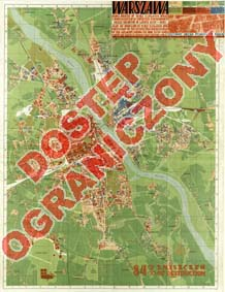
Title: Warszawa : mapa miasta w skali 1:20 000 wraz z inwentaryzacją zniszczeń popełnionych przez Niemców w latach 1939-1945 : nazwy ulic zgodne ze stanem z dnia 1 stycznia 1948 r. = Map of Warsaw at scale 1:20 000 and inventory of destruction perpetrated by the Germans during the war 1939-1945
Subtitle:
Map of Warsaw at scale 1:20 000 and inventory of destruction perpetrated by the Germans during the war 1939-1945 ; Mapa zniszczeń Warszawy w skali 1:20 000 : nazwy ulic aktualne na dzień 1 .I. 1949 r. ; Warszawa : mapa zniszczeń
Contributor:
Kowalski, L. : Oprac. (kartografia) ; Piątkowski, Felicjan (1908–2004) : Oprac. ; Polska. Główny Urząd Pomiarów Kraju
Publisher:
Place of publishing:
Description:
Skala 1:20 000 ; 1 mapa : kolor. ; 96x72 cm, złoż. w okł. 20x33 cm tekst : 27 s. ; 19 cm. ; Tyt. z mapy ; Żródła: ze zdjęć lotniczych wykonanych w 1945 r. przez lotników radzieckich ale Biura Odbudowy Stolicy ; Naniesiona siatka skorowidzowa ; Wykaz nazw : ulice i place
Detailed Resource Type:
Format:
Resource Identifier:
Source:
CBGiOŚ. IGiPZ PAN, call no. D.17551 [pl.m.pow.1] ; CBGiOŚ. IGiPZ PAN, call no. PTG D.710 [pl.m.pow.27] ; click here to follow the link
Language:
Rights:
Rights Reserved - Restricted Access
Terms of use:
Digitizing institution:
Institute of Geography and Spatial Organization of the Polish Academy of Sciences
Original in:
Projects co-financed by:
Programme Innovative Economy, 2010-2014, Priority Axis 2. R&D infrastructure ; European Union. European Regional Development Fund
Access:
Object collections:
- Institute of Geography and Spatial Organization PAS (IGiPZ PAN) > Library
- Institute of Geography and Spatial Organization PAS (IGiPZ PAN) > Library > Maps and atlases
- Institute of Geography and Spatial Organization PAS (IGiPZ PAN) > Library > Selected collections > Polish Geographical Society Collection
Last modified:
Oct 2, 2020
In our library since:
Aug 9, 2013
Number of object content downloads / hits:
72
All available object's versions:
https://rcin.org.pl/igipz/publication/36982

 INSTYTUT ARCHEOLOGII I ETNOLOGII POLSKIEJ AKADEMII NAUK
 INSTYTUT BADAŃ LITERACKICH POLSKIEJ AKADEMII NAUK
 INSTYTUT BADAWCZY LEŚNICTWA
 INSTYTUT BIOLOGII DOŚWIADCZALNEJ IM. MARCELEGO NENCKIEGO POLSKIEJ AKADEMII NAUK
 INSTYTUT BIOLOGII SSAKÓW POLSKIEJ AKADEMII NAUK
 INSTYTUT CHEMII FIZYCZNEJ PAN
 INSTYTUT CHEMII ORGANICZNEJ PAN
 INSTYTUT FILOZOFII I SOCJOLOGII PAN
 INSTYTUT GEOGRAFII I PRZESTRZENNEGO ZAGOSPODAROWANIA PAN
 INSTYTUT HISTORII im. TADEUSZA MANTEUFFLA POLSKIEJ AKADEMII NAUK
 INSTYTUT JĘZYKA POLSKIEGO POLSKIEJ AKADEMII NAUK
 INSTYTUT MATEMATYCZNY PAN
 INSTYTUT MEDYCYNY DOŚWIADCZALNEJ I KLINICZNEJ IM.MIROSŁAWA MOSSAKOWSKIEGO POLSKIEJ AKADEMII NAUK
 INSTYTUT PODSTAWOWYCH PROBLEMÓW TECHNIKI PAN
 INSTYTUT SLAWISTYKI PAN
 SIEĆ BADAWCZA ŁUKASIEWICZ - INSTYTUT TECHNOLOGII MATERIAŁÓW ELEKTRONICZNYCH
 MUZEUM I INSTYTUT ZOOLOGII POLSKIEJ AKADEMII NAUK
 INSTYTUT BADAŃ SYSTEMOWYCH PAN
 INSTYTUT BOTANIKI IM. WŁADYSŁAWA SZAFERA POLSKIEJ AKADEMII NAUK


