- O repozytorium
- Kolekcje
- Indeksy
- Historia przeglądania
-
Repozytoria RCIN
-
 INSTYTUT ARCHEOLOGII I ETNOLOGII POLSKIEJ AKADEMII NAUK
-
 INSTYTUT BADAŃ LITERACKICH POLSKIEJ AKADEMII NAUK
-
 INSTYTUT BADAWCZY LEŚNICTWA
-
 INSTYTUT BIOLOGII DOŚWIADCZALNEJ IM. MARCELEGO NENCKIEGO POLSKIEJ AKADEMII NAUK
-
 INSTYTUT BIOLOGII SSAKÓW POLSKIEJ AKADEMII NAUK
-
 INSTYTUT CHEMII FIZYCZNEJ PAN
-
 INSTYTUT CHEMII ORGANICZNEJ PAN
-
 INSTYTUT FILOZOFII I SOCJOLOGII PAN
-
 INSTYTUT GEOGRAFII I PRZESTRZENNEGO ZAGOSPODAROWANIA PAN
-
 INSTYTUT HISTORII im. TADEUSZA MANTEUFFLA POLSKIEJ AKADEMII NAUK
-
 INSTYTUT JĘZYKA POLSKIEGO POLSKIEJ AKADEMII NAUK
-
 INSTYTUT MATEMATYCZNY PAN
-
 INSTYTUT MEDYCYNY DOŚWIADCZALNEJ I KLINICZNEJ IM.MIROSŁAWA MOSSAKOWSKIEGO POLSKIEJ AKADEMII NAUK
-
 INSTYTUT PODSTAWOWYCH PROBLEMÓW TECHNIKI PAN
-
 INSTYTUT SLAWISTYKI PAN
-
 SIEĆ BADAWCZA ŁUKASIEWICZ - INSTYTUT TECHNOLOGII MATERIAŁÓW ELEKTRONICZNYCH
-
 MUZEUM I INSTYTUT ZOOLOGII POLSKIEJ AKADEMII NAUK
-
 INSTYTUT BADAŃ SYSTEMOWYCH PAN
-
 INSTYTUT BOTANIKI IM. WŁADYSŁAWA SZAFERA POLSKIEJ AKADEMII NAUK
-

Obiekt
Dostępne formaty:
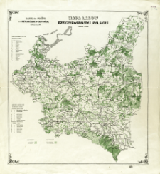
Pobierz wszystkieTytuł: Mapa lasów Rzeczypospolitej Polskiej : podziałka 1:2.000.000 = Carte des ferêts de la Rèpublique Polonaise : èchelle 1:2.000.000
Inny tytuł:
Carte des ferêts de la Republique Polonaise
Współtwórca:
Towarzystwo Kartograficzno-Wydawnicze GEA ; Zakład Graficzny W. Cukrzyński
Wydawca:
T-wo Kartograficzno-Wydawnicze GEA ; Zakł. Graf. W. Cukrzyński
Miejsce wydania:
Opis:
Scale 1:2 000 000 ; 1 map : col. ; 47x43 cm ; The map shows more important forests and division into state and private forests ; Title and legend of map in Polish and French
Szczegółowy typ zasobu:
Format:
Identyfikator zasobu:
Źródło:
CBGiOŚ. IGiPZ PAN, call no. PTG D.691 [2] [m.biogeogr.3] ; kliknij tutaj, żeby przejść
Język:
Prawa:
Zasady wykorzystania:
Digitalizacja:
Institute of Geography and Spatial Organization of the Polish Academy of Sciences
Lokalizacja oryginału:
Dofinansowane ze środków:
Programme Innovative Economy, 2010-2014, Priority Axis 2. R&D infrastructure ; European Union. European Regional Development Fund
Dostęp:
Kolekcje, do których przypisany jest obiekt:
- Instytut Geografii i Przestrzennego Zagospodarowania PAN > Biblioteka Instytutu
- Instytut Geografii i Przestrzennego Zagospodarowania PAN > Biblioteka Instytutu > Mapy i atlasy
- Instytut Geografii i Przestrzennego Zagospodarowania PAN > Biblioteka Instytutu > Wybrane księgozbiory > Księgozbiór Polskiego Towarzystwa Geograficznego
Data ostatniej modyfikacji:
19 wrz 2024
Data dodania obiektu:
25 cze 2013
Liczba pobrań / odtworzeń:
265
Wszystkie dostępne wersje tego obiektu:
https://rcin.org.pl/igipz/publication/40501
Wyświetl opis w formacie RDF:
Wyświetl opis w formacie RDFa:
Wyświetl opis w formacie OAI-PMH:
| Nazwa wydania | Data |
|---|---|
| Mapa lasów Rzeczypospolitej Polskiej = Carte des ferêts de la Rèpublique Polonaise, [ca 1918] | 19 wrz 2024 |
Obiekty Podobne
Matuszkiewicz, Jan Marek (1946– ) Wolski, Jacek (1971– ) Kowalska, Anna (1977– )
Mochnacki, Rodion (1898–1981)
Prusy. Ministerium der Öffentlichen Arbeiten. Kartographischen Bureau Prusy. Ministerium für Landwirtschaft, Domänen und Forsten. Forsteinrichtungs - Bureau


