Object
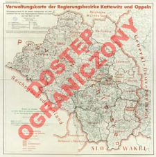
Title: Verwaltungskarte der Regierungsbezirke Kattowitz und Oppeln : Gemeindegrenzenkarte für die ehemals reichsdeutschen und österreichischen Teile der neuen Regierungsbezirke Kattowitz und Oppeln nach dem Stand von 1914
Contributor:
Ost, Horst Gotthard : Oprac. ; Doubek, Franz A : Oprac. ; Publikationsstelle Berlin-Dahlem
Publisher:
Reichsministerium des Innern Publikationsstelle
Place of publishing:
Description:
Skala 1:300 000 ; Na mapie zaznaczone kolorem: Grenzen von Versailles und letzter Stand der polnischen Verwaltungseinteilung vor der Neuordnung des Ostraumes 1938/39. / Bearb. v. K. v. Maydell ; Die Verwaltungseinteilung nach der Neuordnung des Ostraumes. Bearb. v. F. A. Doubek ; Tyt. z mapy ; Brak prezentacji rzeźby ; 1 mapa : kolor. ; 72x72 cm, na ark. 82x86 cm ; DNB online
Detailed Resource Type:
Format:
Resource Identifier:
Source:
CBGiOŚ. IGiPZ PAN, call no. D.20145 [m.polit.-adm.Śląsk.3] ; click here to follow the link
Language:
Rights:
Rights Reserved - Restricted Access
Terms of use:
Digitizing institution:
Institute of Geography and Spatial Organization of the Polish Academy of Sciences
Original in:
Projects co-financed by:
Programme Innovative Economy, 2010-2014, Priority Axis 2. R&D infrastructure ; European Union. European Regional Development Fund
Access:
Object collections:
- Institute of Geography and Spatial Organization PAS (IGiPZ PAN) > Library
- Institute of Geography and Spatial Organization PAS (IGiPZ PAN) > Library > Maps and atlases
Last modified:
Oct 2, 2020
In our library since:
May 31, 2013
Number of object content downloads / hits:
66
All available object's versions:
https://rcin.org.pl/igipz/publication/41314
Show description in RDF format:
Show description in RDFa format:
Show description in OAI-PMH format:
Objects Similar
Instytut Gospodarstwa Społecznego
Kaiserlich-Königliches Militär-Geographisches Institut (Wiedeń). Instytucja sprawcza. Wydawca

 INSTYTUT ARCHEOLOGII I ETNOLOGII POLSKIEJ AKADEMII NAUK
 INSTYTUT BADAŃ LITERACKICH POLSKIEJ AKADEMII NAUK
 INSTYTUT BADAWCZY LEŚNICTWA
 INSTYTUT BIOLOGII DOŚWIADCZALNEJ IM. MARCELEGO NENCKIEGO POLSKIEJ AKADEMII NAUK
 INSTYTUT BIOLOGII SSAKÓW POLSKIEJ AKADEMII NAUK
 INSTYTUT CHEMII FIZYCZNEJ PAN
 INSTYTUT CHEMII ORGANICZNEJ PAN
 INSTYTUT FILOZOFII I SOCJOLOGII PAN
 INSTYTUT GEOGRAFII I PRZESTRZENNEGO ZAGOSPODAROWANIA PAN
 INSTYTUT HISTORII im. TADEUSZA MANTEUFFLA POLSKIEJ AKADEMII NAUK
 INSTYTUT JĘZYKA POLSKIEGO POLSKIEJ AKADEMII NAUK
 INSTYTUT MATEMATYCZNY PAN
 INSTYTUT MEDYCYNY DOŚWIADCZALNEJ I KLINICZNEJ IM.MIROSŁAWA MOSSAKOWSKIEGO POLSKIEJ AKADEMII NAUK
 INSTYTUT PODSTAWOWYCH PROBLEMÓW TECHNIKI PAN
 INSTYTUT SLAWISTYKI PAN
 SIEĆ BADAWCZA ŁUKASIEWICZ - INSTYTUT TECHNOLOGII MATERIAŁÓW ELEKTRONICZNYCH
 MUZEUM I INSTYTUT ZOOLOGII POLSKIEJ AKADEMII NAUK
 INSTYTUT BADAŃ SYSTEMOWYCH PAN
 INSTYTUT BOTANIKI IM. WŁADYSŁAWA SZAFERA POLSKIEJ AKADEMII NAUK


