- About project
- Collections
- Indexes
- Recently viewed
-
RCIN Repositories
-
 INSTYTUT ARCHEOLOGII I ETNOLOGII POLSKIEJ AKADEMII NAUK
-
 INSTYTUT BADAŃ LITERACKICH POLSKIEJ AKADEMII NAUK
-
 INSTYTUT BADAWCZY LEŚNICTWA
-
 INSTYTUT BIOLOGII DOŚWIADCZALNEJ IM. MARCELEGO NENCKIEGO POLSKIEJ AKADEMII NAUK
-
 INSTYTUT BIOLOGII SSAKÓW POLSKIEJ AKADEMII NAUK
-
 INSTYTUT CHEMII FIZYCZNEJ PAN
-
 INSTYTUT CHEMII ORGANICZNEJ PAN
-
 INSTYTUT FILOZOFII I SOCJOLOGII PAN
-
 INSTYTUT GEOGRAFII I PRZESTRZENNEGO ZAGOSPODAROWANIA PAN
-
 INSTYTUT HISTORII im. TADEUSZA MANTEUFFLA POLSKIEJ AKADEMII NAUK
-
 INSTYTUT JĘZYKA POLSKIEGO POLSKIEJ AKADEMII NAUK
-
 INSTYTUT MATEMATYCZNY PAN
-
 INSTYTUT MEDYCYNY DOŚWIADCZALNEJ I KLINICZNEJ IM.MIROSŁAWA MOSSAKOWSKIEGO POLSKIEJ AKADEMII NAUK
-
 INSTYTUT PODSTAWOWYCH PROBLEMÓW TECHNIKI PAN
-
 INSTYTUT SLAWISTYKI PAN
-
 SIEĆ BADAWCZA ŁUKASIEWICZ - INSTYTUT TECHNOLOGII MATERIAŁÓW ELEKTRONICZNYCH
-
 MUZEUM I INSTYTUT ZOOLOGII POLSKIEJ AKADEMII NAUK
-
 INSTYTUT BADAŃ SYSTEMOWYCH PAN
-
 INSTYTUT BOTANIKI IM. WŁADYSŁAWA SZAFERA POLSKIEJ AKADEMII NAUK
-

Object
Available formats:
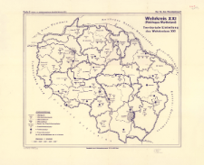
Download allTitle: Wehrkreis XXI (Reichsgau Wartheland) : Territoriale Einteilung des Wehrkreises XXI
Subtitle:
Territoriale Einteilung des Wehrkreises XXI ; Karte 2 (Anlage 2 zu "Militärgeographischer Überblick Wehrkreis XXI")
Institutional creator:
Niemcy. Wehrmacht. Wehrkreiskommando XXI.
Publisher:
Place of publishing:
Description:
Skala 1:500 000 ; 1 mapa ; 54 x 63 cm, na arkuszu 70 x 86 cm ; Mapa wchodzi w skład zestawu: Militärgeographischer Überblick, Wehrkreis XXI (Reichsgau Wartheland): abgeschlossen am 1. Juli 1941. - Posen, 1941 ; Mapa przedstawia niemiecki, wojskowy podział terytorialny Kraju Warty
Type of object:
Detailed Resource Type:
Resource Identifier:
Source:
CBGiOŚ. IGiPZ PAN, sygn. D.2199/1 ; click here to follow the link
Language:
Rights:
Terms of use:
Digitizing institution:
Instytut Geografii i Przestrzennego Zagospodarowania Polskiej Akademii Nauk
Original in:
Projects co-financed by:
Access:
Object collections:
- Institute of Geography and Spatial Organization PAS (IGiPZ PAN) > Library
- Institute of Geography and Spatial Organization PAS (IGiPZ PAN) > Library > Maps and atlases
Last modified:
Sep 13, 2021
In our library since:
Sep 9, 2021
Number of object content downloads / hits:
166
All available object's versions:
https://rcin.org.pl/igipz/publication/45655
Show description in RDF format:
Show description in RDFa format:
Show description in OAI-PMH format:
| Edition name | Date |
|---|---|
| Wehrkreis XXI (Reichsgau Wartheland) : Territoriale Einteilung des Wehrkreises XXI, [1941] | Sep 13, 2021 |
Objects Similar
Niemcy. Reichsstatthalter im Warthegau. Raumordnung und Landesplanung
Francja. Service Géographique des forces françaises libres au Levant. Wydawca


