Object
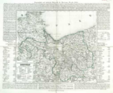
Title: Charte vom Königlich Preussischen Regierungsbezirk Stettin : nach seiner Eintheilung in 12 Kreise
Subtitle:
Geographishe und statistische Uebersicht des Regierugs - Bezirks Stettin
Contributor:
Publisher:
Verlag der J. C. Müller'schen Buchhandlung
Place of publishing:
Description:
Skala [ca 1:560 000], podziałka geographische Meilen ; 1 mapa : litogr., kolor. ręcznie ; 34x38 cm, na ark.48x 56 cm ; Tyt. z ramki w lewym dolnym rogu mapy ; Południk zerowy Ferro ; Wokół mapy tekst z inform. geograficzną i statystyczną ; Data wyd. wg informacji w tekscie objaśniającym ; Pod mapą: Steindr. v. Aug. Kneisel in Leipzig
Detailed Resource Type:
Format:
Resource Identifier:
Source:
CBGiOŚ. IGiPZ PAN, call no. D.2122 [T.6/9] ; click here to follow the link
Language:
Rights:
Terms of use:
Digitizing institution:
Institute of Geography and Spatial Organization of the Polish Academy of Sciences
Original in:
Projects co-financed by:
Programme Innovative Economy, 2010-2014, Priority Axis 2. R&D infrastructure ; European Union. European Regional Development Fund
Access:
Object collections:
- Institute of Geography and Spatial Organization PAS (IGiPZ PAN) > Library
- Institute of Geography and Spatial Organization PAS (IGiPZ PAN) > Library > Maps and atlases
Last modified:
Oct 2, 2020
In our library since:
Jan 24, 2014
Number of object content downloads / hits:
106
All available object's versions:
https://rcin.org.pl/igipz/publication/51485
Show description in RDF format:
Show description in RDFa format:
Show description in OAI-PMH format:
| Edition name | Date |
|---|---|
| Charte vom Königlich Preussischen Regierungsbezirk Stettin : nach seiner Eintheilung in 12 Kreise, [post 1843] | Oct 2, 2020 |
Objects Similar
Rappard, F. von (fl. 1850-1870)
Robert de Vaugondy, Gilles (1688–1766)

 INSTYTUT ARCHEOLOGII I ETNOLOGII POLSKIEJ AKADEMII NAUK
 INSTYTUT BADAŃ LITERACKICH POLSKIEJ AKADEMII NAUK
 INSTYTUT BADAWCZY LEŚNICTWA
 INSTYTUT BIOLOGII DOŚWIADCZALNEJ IM. MARCELEGO NENCKIEGO POLSKIEJ AKADEMII NAUK
 INSTYTUT BIOLOGII SSAKÓW POLSKIEJ AKADEMII NAUK
 INSTYTUT CHEMII FIZYCZNEJ PAN
 INSTYTUT CHEMII ORGANICZNEJ PAN
 INSTYTUT FILOZOFII I SOCJOLOGII PAN
 INSTYTUT GEOGRAFII I PRZESTRZENNEGO ZAGOSPODAROWANIA PAN
 INSTYTUT HISTORII im. TADEUSZA MANTEUFFLA POLSKIEJ AKADEMII NAUK
 INSTYTUT JĘZYKA POLSKIEGO POLSKIEJ AKADEMII NAUK
 INSTYTUT MATEMATYCZNY PAN
 INSTYTUT MEDYCYNY DOŚWIADCZALNEJ I KLINICZNEJ IM.MIROSŁAWA MOSSAKOWSKIEGO POLSKIEJ AKADEMII NAUK
 INSTYTUT PODSTAWOWYCH PROBLEMÓW TECHNIKI PAN
 INSTYTUT SLAWISTYKI PAN
 SIEĆ BADAWCZA ŁUKASIEWICZ - INSTYTUT TECHNOLOGII MATERIAŁÓW ELEKTRONICZNYCH
 MUZEUM I INSTYTUT ZOOLOGII POLSKIEJ AKADEMII NAUK
 INSTYTUT BADAŃ SYSTEMOWYCH PAN
 INSTYTUT BOTANIKI IM. WŁADYSŁAWA SZAFERA POLSKIEJ AKADEMII NAUK


