- O repozytorium
- Kolekcje
- Indeksy
- Historia przeglądania
-
Repozytoria RCIN
-
 INSTYTUT ARCHEOLOGII I ETNOLOGII POLSKIEJ AKADEMII NAUK
-
 INSTYTUT BADAŃ LITERACKICH POLSKIEJ AKADEMII NAUK
-
 INSTYTUT BADAWCZY LEŚNICTWA
-
 INSTYTUT BIOLOGII DOŚWIADCZALNEJ IM. MARCELEGO NENCKIEGO POLSKIEJ AKADEMII NAUK
-
 INSTYTUT BIOLOGII SSAKÓW POLSKIEJ AKADEMII NAUK
-
 INSTYTUT CHEMII FIZYCZNEJ PAN
-
 INSTYTUT CHEMII ORGANICZNEJ PAN
-
 INSTYTUT FILOZOFII I SOCJOLOGII PAN
-
 INSTYTUT GEOGRAFII I PRZESTRZENNEGO ZAGOSPODAROWANIA PAN
-
 INSTYTUT HISTORII im. TADEUSZA MANTEUFFLA POLSKIEJ AKADEMII NAUK
-
 INSTYTUT JĘZYKA POLSKIEGO POLSKIEJ AKADEMII NAUK
-
 INSTYTUT MATEMATYCZNY PAN
-
 INSTYTUT MEDYCYNY DOŚWIADCZALNEJ I KLINICZNEJ IM.MIROSŁAWA MOSSAKOWSKIEGO POLSKIEJ AKADEMII NAUK
-
 INSTYTUT PODSTAWOWYCH PROBLEMÓW TECHNIKI PAN
-
 INSTYTUT SLAWISTYKI PAN
-
 SIEĆ BADAWCZA ŁUKASIEWICZ - INSTYTUT TECHNOLOGII MATERIAŁÓW ELEKTRONICZNYCH
-
 MUZEUM I INSTYTUT ZOOLOGII POLSKIEJ AKADEMII NAUK
-
 INSTYTUT BADAŃ SYSTEMOWYCH PAN
-
 INSTYTUT BOTANIKI IM. WŁADYSŁAWA SZAFERA POLSKIEJ AKADEMII NAUK
-

Obiekt
Dostępne formaty:
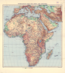
Pobierz wszystkieTytuł: Physikalische Karte von Afrika und Westasien
Wydawca:
Miejsce wydania:
Opis:
Scale 1:10 000 000 ; 1 map : color. ; 93x89 cm, on sheet 109x98 cm ; In the bottom corner of the map: IV. 1941
Szczegółowy typ zasobu:
Format:
Identyfikator zasobu:
Źródło:
CBGiOŚ. IGiPZ PAN, call no. D.19728 ; kliknij tutaj, żeby przejść
Język:
Zakres:
Prawa:
Zasady wykorzystania:
Digitalizacja:
Institute of Geography and Spatial Organization of the Polish Academy of Sciences
Lokalizacja oryginału:
Dofinansowane ze środków:
Dostęp:
Kolekcje, do których przypisany jest obiekt:
Data ostatniej modyfikacji:
2 paź 2020
Data dodania obiektu:
21 sty 2020
Liczba pobrań / odtworzeń:
32
Wszystkie dostępne wersje tego obiektu:
https://rcin.org.pl/igipz/publication/107926
Wyświetl opis w formacie RDF:
Wyświetl opis w formacie RDFa:
Wyświetl opis w formacie OAI-PMH:
| Nazwa wydania | Data |
|---|---|
| Physikalische Karte von Afrika und Westasien, 1941 | 2 paź 2020 |
Obiekty Podobne
Bazewicz, Józef Michał (c. 1862 – 1928) Zakład Litografia Artystyczna W. Główczewski (Warszawa). Drukarz
Wielka Brytania. War Office. Redaktor Wydawca Wielka Brytania. Ordnance Survey. Rysownik. Drukarz
George Philip and Son. Wydawca London Geographical Institute. Instytucja sprawcza
Niemcy. Heer. Generalstab. Abteilung für Kriegskarten und Vermessungswesen. Redaktor Niemcy. Heer. Heeresplankammer. Wydawca
Niemcy. Heer. Generalstab. Abteilung für Kriegskarten und Vermessungswesen. Redaktor Niemcy. Heer. Heeresplankammer. Redaktor Wydawca
Niemcy. Heer. Generalstab. Abteilung für Kriegskarten und Vermessungswesen. Redaktor Niemcy. Heer. Heeresplankammer. Wydawca
Stany Zjednoczone. Army Map Service. Wydawca Stany Zjednoczone. Army. Office of the Chief Engineers. Redaktor


