- About project
- Collections
- Indexes
- Recently viewed
-
RCIN Repositories
-
 INSTYTUT ARCHEOLOGII I ETNOLOGII POLSKIEJ AKADEMII NAUK
-
 INSTYTUT BADAŃ LITERACKICH POLSKIEJ AKADEMII NAUK
-
 INSTYTUT BADAWCZY LEŚNICTWA
-
 INSTYTUT BIOLOGII DOŚWIADCZALNEJ IM. MARCELEGO NENCKIEGO POLSKIEJ AKADEMII NAUK
-
 INSTYTUT BIOLOGII SSAKÓW POLSKIEJ AKADEMII NAUK
-
 INSTYTUT CHEMII FIZYCZNEJ PAN
-
 INSTYTUT CHEMII ORGANICZNEJ PAN
-
 INSTYTUT FILOZOFII I SOCJOLOGII PAN
-
 INSTYTUT GEOGRAFII I PRZESTRZENNEGO ZAGOSPODAROWANIA PAN
-
 INSTYTUT HISTORII im. TADEUSZA MANTEUFFLA POLSKIEJ AKADEMII NAUK
-
 INSTYTUT JĘZYKA POLSKIEGO POLSKIEJ AKADEMII NAUK
-
 INSTYTUT MATEMATYCZNY PAN
-
 INSTYTUT MEDYCYNY DOŚWIADCZALNEJ I KLINICZNEJ IM.MIROSŁAWA MOSSAKOWSKIEGO POLSKIEJ AKADEMII NAUK
-
 INSTYTUT PODSTAWOWYCH PROBLEMÓW TECHNIKI PAN
-
 INSTYTUT SLAWISTYKI PAN
-
 SIEĆ BADAWCZA ŁUKASIEWICZ - INSTYTUT TECHNOLOGII MATERIAŁÓW ELEKTRONICZNYCH
-
 MUZEUM I INSTYTUT ZOOLOGII POLSKIEJ AKADEMII NAUK
-
 INSTYTUT BADAŃ SYSTEMOWYCH PAN
-
 INSTYTUT BOTANIKI IM. WŁADYSŁAWA SZAFERA POLSKIEJ AKADEMII NAUK
-

Object
Available formats:
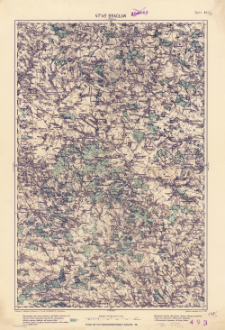
Download allTitle: 47°49° Bracław : podziałka 1:200.000 czyli 1 cm = 2 km
Creator:
Zakłady Graficzne Eugeniusza i dra Kazimierza Koziańskich. Wykonawca ; Instytut Wojskowo-Geograficzny. Wydawca
Date issued/created:
Resource type:
Subtitle:
Publisher:
wydanie Instytutu Wojskowo-Geograficznego
Place of publishing:
Description:
Scale 1:200 000 ; 1 map : color ; 56x38 cm, sheet 65x44 cm ; Date of publication and information about map from: Mapy topograficzne ziem polskich 1871-1945. T. 1 / B. Krassowski, M. Tomaszewska. Warszawa, 1979. This is a reworking sheet from the Austrian general map: Generalkarte von Mitteleuropa, 47°49° Bracław ; Częściowo sprawdzone do 18.IX.1915 ; Prime meridian Ferro
Detailed Resource Type:
Format:
Resource Identifier:
Source:
CBGiOŚ. IGiPZ PAN, call no. C.851/7 ; click here to follow the link
Language:
Spatial coverage:
Rights:
Terms of use:
Digitizing institution:
Institute of Geography and Spatial Organization of the Polish Academy of Sciences
Original in:
Projects co-financed by:
Access:
Object collections:
- Digital Repository of Scientific Institutes > Partners' collections > Institute of Geography and Spatial Organization PAS (IGiPZ PAN) > Library
- Digital Repository of Scientific Institutes > Partners' collections > Institute of Geography and Spatial Organization PAS (IGiPZ PAN) > Library > Maps and atlases
- Digital Repository of Scientific Institutes > Literature > Maps/Atlases
Last modified:
Oct 2, 2020
In our library since:
Dec 17, 2019
Number of object content downloads / hits:
52
All available object's versions:
https://rcin.org.pl/publication/89411
Show description in RDF format:
Show description in RDFa format:
Show description in OAI-PMH format:
| Edition name | Date |
|---|---|
| 47°49° Bracław : podziałka 1:200.000 czyli 1 cm = 2 km, 1920 | Oct 2, 2020 |
Objects Similar
Zakłady Graficzne Eugeniusza i dra Kazimierza Koziańskich. Wykonawca Instytut Wojskowo-Geograficzny. Wydawca
Zakłady Graficzne Eugeniusza i dra Kazimierza Koziańskich. Wykonawca Instytut Wojskowo-Geograficzny. Wydawca
Zakłady Graficzne Eugeniusza i dra Kazimierza Koziańskich. Wykonawca Instytut Wojskowo-Geograficzny. Wydawca
Instytut Wojskowo-Geograficzny. Wydawca Zakłady Graficzne Eugeniusza i dra Kazimierza Koziańskich. Wykonawca
Zakłady Graficzne Eugeniusza i dra Kazimierza Koziańskich. Wykonawca Instytut Wojskowo-Geograficzny. Wydawca
Instytut Wojskowo-Geograficzny. Wydawca
Dokaupil, Roman (18...- 19...). Redaktor Straka, J. Redaktor Bloschitz, Rudolf Macoun, V. Redaktor


