- About project
- Collections
- Indexes
- Recently viewed
-
RCIN Repositories
-
 INSTYTUT ARCHEOLOGII I ETNOLOGII POLSKIEJ AKADEMII NAUK
-
 INSTYTUT BADAŃ LITERACKICH POLSKIEJ AKADEMII NAUK
-
 INSTYTUT BADAWCZY LEŚNICTWA
-
 INSTYTUT BIOLOGII DOŚWIADCZALNEJ IM. MARCELEGO NENCKIEGO POLSKIEJ AKADEMII NAUK
-
 INSTYTUT BIOLOGII SSAKÓW POLSKIEJ AKADEMII NAUK
-
 INSTYTUT CHEMII FIZYCZNEJ PAN
-
 INSTYTUT CHEMII ORGANICZNEJ PAN
-
 INSTYTUT FILOZOFII I SOCJOLOGII PAN
-
 INSTYTUT GEOGRAFII I PRZESTRZENNEGO ZAGOSPODAROWANIA PAN
-
 INSTYTUT HISTORII im. TADEUSZA MANTEUFFLA POLSKIEJ AKADEMII NAUK
-
 INSTYTUT JĘZYKA POLSKIEGO POLSKIEJ AKADEMII NAUK
-
 INSTYTUT MATEMATYCZNY PAN
-
 INSTYTUT MEDYCYNY DOŚWIADCZALNEJ I KLINICZNEJ IM.MIROSŁAWA MOSSAKOWSKIEGO POLSKIEJ AKADEMII NAUK
-
 INSTYTUT PODSTAWOWYCH PROBLEMÓW TECHNIKI PAN
-
 INSTYTUT SLAWISTYKI PAN
-
 SIEĆ BADAWCZA ŁUKASIEWICZ - INSTYTUT TECHNOLOGII MATERIAŁÓW ELEKTRONICZNYCH
-
 MUZEUM I INSTYTUT ZOOLOGII POLSKIEJ AKADEMII NAUK
-
 INSTYTUT BADAŃ SYSTEMOWYCH PAN
-
 INSTYTUT BOTANIKI IM. WŁADYSŁAWA SZAFERA POLSKIEJ AKADEMII NAUK
-

Object
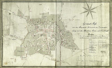
Title: Grund Riss von der Bergstadt Tarnowitz im Zusammen hang mit der Blaschiene, Lischee und Carlshoff
Publisher:
Place of publishing:
Description:
Skala [ca 1:1 960] ; 1 mapa : rps, kolor. ; 54x90 cm, na ark. 57x93 cm ; Orientacja mapy północno-zachodnia ; Pod tyt. adnotacja: Das roth angelegte bestimt die Granze der Blaschiene und der Stadt, das braune bestimt die Grenze der Lischee u.d. Stadt ; Na ark. zamieszczono wykaz urzędów i budynków zaznaczonych literami na planie
Detailed Resource Type:
Format:
Rozmiar pliku 2,7 MB ; image/x.djvu
Resource Identifier:
Source:
CBGiOŚ. IGiPZ PAN, sygn. D.11315 [IX-b61] ; click here to follow the link
Language:
Rights:
Terms of use:
Digitizing institution:
Instytut Geografii i Przestrzennego Zagospodarowania Polskiej Akademii Nauk
Original in:
Projects co-financed by:
Program Operacyjny Innowacyjna Gospodarka, lata 2010-2014, Priorytet 2. Infrastruktura strefy B + R ; Unia Europejska. Europejski Fundusz Rozwoju Regionalnego
Access:
Object collections:
- Digital Repository of Scientific Institutes > Partners' collections > Institute of Geography and Spatial Organization PAS (IGiPZ PAN) > Library
- Digital Repository of Scientific Institutes > Partners' collections > Institute of Geography and Spatial Organization PAS (IGiPZ PAN) > Library > Maps and atlases
- Digital Repository of Scientific Institutes > Literature > Maps/Atlases
Last modified:
Oct 2, 2020
In our library since:
Aug 2, 2012
Number of object content downloads / hits:
312
All available object's versions:
https://rcin.org.pl/publication/15394
Show description in RDF format:
Show description in RDFa format:
Show description in OAI-PMH format:
| Edition name | Date |
|---|---|
| Gärtner, I. G., 1805, Grund Riss von der Bergstadt Tarnowitz im Zusammen hang mit der Blaschiene, Lischee und Carlshoff | Oct 2, 2020 |
Objects Similar
Skimborowicz, Hipolit Red. Zakrzewski, Walenty Red. Jenike, Ludwik Red.
Skimborowicz, Hipolit Red. Zakrzewski, Walenty Red. Jenike, Ludwik Red.
Skimborowicz, Hipolit Red. Zakrzewski, Walenty Red. Jenike, Ludwik Red.
Skimborowicz, Hipolit Red. Zakrzewski, Walenty Red. Jenike, Ludwik Red.
Skimborowicz, Hipolit Red. Zakrzewski, Walenty Red. Jenike, Ludwik Red.
Skimborowicz, Hipolit Red. Zakrzewski, Walenty Red. Jenike, Ludwik Red.
Skimborowicz, Hipolit Red. Zakrzewski, Walenty Red. Jenike, Ludwik Red.
Skimborowicz, Hipolit Red. Zakrzewski, Walenty Red. Jenike, Ludwik Red.


