- About project
- Collections
- Indexes
- Recently viewed
-
RCIN Repositories
-
 INSTYTUT ARCHEOLOGII I ETNOLOGII POLSKIEJ AKADEMII NAUK
-
 INSTYTUT BADAŃ LITERACKICH POLSKIEJ AKADEMII NAUK
-
 INSTYTUT BADAWCZY LEŚNICTWA
-
 INSTYTUT BIOLOGII DOŚWIADCZALNEJ IM. MARCELEGO NENCKIEGO POLSKIEJ AKADEMII NAUK
-
 INSTYTUT BIOLOGII SSAKÓW POLSKIEJ AKADEMII NAUK
-
 INSTYTUT CHEMII FIZYCZNEJ PAN
-
 INSTYTUT CHEMII ORGANICZNEJ PAN
-
 INSTYTUT FILOZOFII I SOCJOLOGII PAN
-
 INSTYTUT GEOGRAFII I PRZESTRZENNEGO ZAGOSPODAROWANIA PAN
-
 INSTYTUT HISTORII im. TADEUSZA MANTEUFFLA POLSKIEJ AKADEMII NAUK
-
 INSTYTUT JĘZYKA POLSKIEGO POLSKIEJ AKADEMII NAUK
-
 INSTYTUT MATEMATYCZNY PAN
-
 INSTYTUT MEDYCYNY DOŚWIADCZALNEJ I KLINICZNEJ IM.MIROSŁAWA MOSSAKOWSKIEGO POLSKIEJ AKADEMII NAUK
-
 INSTYTUT PODSTAWOWYCH PROBLEMÓW TECHNIKI PAN
-
 INSTYTUT SLAWISTYKI PAN
-
 SIEĆ BADAWCZA ŁUKASIEWICZ - INSTYTUT TECHNOLOGII MATERIAŁÓW ELEKTRONICZNYCH
-
 MUZEUM I INSTYTUT ZOOLOGII POLSKIEJ AKADEMII NAUK
-
 INSTYTUT BADAŃ SYSTEMOWYCH PAN
-
 INSTYTUT BOTANIKI IM. WŁADYSŁAWA SZAFERA POLSKIEJ AKADEMII NAUK
-

Object
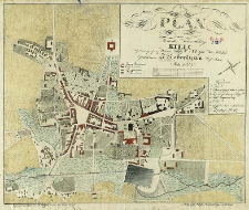
Title: Plan miasta woiewodzkiego Kielc
Subtitle:
Plan miasta wojewódzkiego Kielc
Publisher:
[s.n.] ; (W Litografii Filipa Zielińskiego)
Place of publishing:
Description:
Scale [ca 1:4 300] ; 1 map : lithogr., col. ; 34x40 cm ; Wymierzony przez uczniów klasy V i VI szkół woie. kieleckich pod dozorem J. Sobertyna prof. matem ; rys. na kamieniu P. Wetzlich uczeń klas. VI J. W. K. ; Cited in: Historische Pläne und Grundrisse von Städten und Ortschaften in Polen, poz. 1491
Detailed Resource Type:
Format:
File size 1,6 MB ; image/x.djvu
Resource Identifier:
Source:
CBGiOŚ. IGiPZ PAN, call no. Ds.8021 [IX.11B-18] ; click here to follow the link
Language:
Rights:
Terms of use:
Digitizing institution:
Institute of Geography and Spatial Organization of the Polish Academy of Sciences
Original in:
Projects co-financed by:
Programme Innovative Economy, 2010-2014, Priority Axis 2. R&D infrastructure ; European Union. European Regional Development Fund
Access:
Object collections:
- Digital Repository of Scientific Institutes > Partners' collections > Institute of Geography and Spatial Organization PAS (IGiPZ PAN) > Library
- Digital Repository of Scientific Institutes > Partners' collections > Institute of Geography and Spatial Organization PAS (IGiPZ PAN) > Library > Maps and atlases
- Digital Repository of Scientific Institutes > Literature > Maps/Atlases
Last modified:
Oct 2, 2020
In our library since:
Sep 16, 2011
Number of object content downloads / hits:
479
All available object's versions:
https://rcin.org.pl/publication/2677
Show description in RDF format:
Show description in RDFa format:
Show description in OAI-PMH format:
| Edition name | Date |
|---|---|
| Wetzlich, P Rys., Sobertyn J. Red. 1828, Plan miasta woiewodzkiego Kielc | Oct 2, 2020 |
Objects Similar
Skimborowicz, Hipolit Red. Zakrzewski, Walenty Red. Jenike, Ludwik Red.
Skimborowicz, Hipolit Red. Zakrzewski, Walenty Red. Jenike, Ludwik Red.
Skimborowicz, Hipolit Red. Zakrzewski, Walenty Red. Jenike, Ludwik Red.
Skimborowicz, Hipolit Red. Zakrzewski, Walenty Red. Jenike, Ludwik Red.
Skimborowicz, Hipolit Red. Zakrzewski, Walenty Red. Jenike, Ludwik Red.
Skimborowicz, Hipolit Red. Zakrzewski, Walenty Red. Jenike, Ludwik Red.
Skimborowicz, Hipolit Red. Zakrzewski, Walenty Red. Jenike, Ludwik Red.
Skimborowicz, Hipolit Red. Zakrzewski, Walenty Red. Jenike, Ludwik Red.


