- About project
- Collections
- Indexes
- Recently viewed
-
RCIN Repositories
-
 INSTYTUT ARCHEOLOGII I ETNOLOGII POLSKIEJ AKADEMII NAUK
-
 INSTYTUT BADAŃ LITERACKICH POLSKIEJ AKADEMII NAUK
-
 INSTYTUT BADAWCZY LEŚNICTWA
-
 INSTYTUT BIOLOGII DOŚWIADCZALNEJ IM. MARCELEGO NENCKIEGO POLSKIEJ AKADEMII NAUK
-
 INSTYTUT BIOLOGII SSAKÓW POLSKIEJ AKADEMII NAUK
-
 INSTYTUT CHEMII FIZYCZNEJ PAN
-
 INSTYTUT CHEMII ORGANICZNEJ PAN
-
 INSTYTUT FILOZOFII I SOCJOLOGII PAN
-
 INSTYTUT GEOGRAFII I PRZESTRZENNEGO ZAGOSPODAROWANIA PAN
-
 INSTYTUT HISTORII im. TADEUSZA MANTEUFFLA POLSKIEJ AKADEMII NAUK
-
 INSTYTUT JĘZYKA POLSKIEGO POLSKIEJ AKADEMII NAUK
-
 INSTYTUT MATEMATYCZNY PAN
-
 INSTYTUT MEDYCYNY DOŚWIADCZALNEJ I KLINICZNEJ IM.MIROSŁAWA MOSSAKOWSKIEGO POLSKIEJ AKADEMII NAUK
-
 INSTYTUT PODSTAWOWYCH PROBLEMÓW TECHNIKI PAN
-
 INSTYTUT SLAWISTYKI PAN
-
 SIEĆ BADAWCZA ŁUKASIEWICZ - INSTYTUT TECHNOLOGII MATERIAŁÓW ELEKTRONICZNYCH
-
 MUZEUM I INSTYTUT ZOOLOGII POLSKIEJ AKADEMII NAUK
-
 INSTYTUT BADAŃ SYSTEMOWYCH PAN
-
 INSTYTUT BOTANIKI IM. WŁADYSŁAWA SZAFERA POLSKIEJ AKADEMII NAUK
-

Object
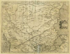
Title: Evropae Tabvla. IX. Continet Iazyges Metanastas Daciam Mysiam superiorem, Mysiam inferiorem, & Thraciam
Subtitle:
Europae Tabula IX ; Evr: IX Tab
Contributor:
Mercator, Gerard (1512–1594) : Oprac. ; Kempen, Gottfried von (15..-1598?). Druk.
Publisher:
Place of publishing:
Description:
Skala [ca 1:2 700 000] ; 1 mapa : miedzior. ; 35x45 cm ; Rzeźba terenu przedst. metodą kopczykową ; Mapa pochodzi z atlasu: Tabvlae Geographicae Cl. Ptolem[aei] ad mentem autoris restitutae & emendatae / per Gerardum Mercatorem iIlustriss: ducis Cliui[ae] etc: Cosmographu[m], wydawanym przez Gotfrieda von Kempena w roku 1578 i 1584] ; Na odwrocie k. opis współrzędnych poszczególnych terenów
Detailed Resource Type:
Format:
Resource Identifier:
Source:
CBGiOŚ. IGiPZ PAN, call no. B.KS.448/1 ; click here to follow the link
Language:
Rights:
Terms of use:
Digitizing institution:
Institute of Geography and Spatial Organization of the Polish Academy of Sciences
Original in:
Projects co-financed by:
Programme Innovative Economy, 2010-2014, Priority Axis 2. R&D infrastructure ; European Union. European Regional Development Fund
Access:
Object collections:
- Digital Repository of Scientific Institutes > Partners' collections > Institute of Geography and Spatial Organization PAS (IGiPZ PAN) > Library
- Digital Repository of Scientific Institutes > Partners' collections > Institute of Geography and Spatial Organization PAS (IGiPZ PAN) > Library > Maps and atlases
- Digital Repository of Scientific Institutes > Partners' collections > Institute of Geography and Spatial Organization PAS (IGiPZ PAN) > Library > Selected collections > Polish Geographical Society Collection
- Digital Repository of Scientific Institutes > Partners' collections > Institute of Geography and Spatial Organization PAS (IGiPZ PAN) > Library > Selected collections > Prof. Józef Staszewski Collection
- Digital Repository of Scientific Institutes > Literature > Maps/Atlases
Last modified:
Oct 2, 2020
In our library since:
Oct 9, 2013
Number of object content downloads / hits:
149
All available object's versions:
https://rcin.org.pl/publication/39534
Show description in RDF format:
Show description in RDFa format:
Show description in OAI-PMH format:
| Edition name | Date |
|---|---|
| Ptolemaeus, Claudius (ca 100-ca 178), [ca 1584], Evropae Tabvla IX | Oct 2, 2020 |
Objects Similar
Ptolemaeus, Claudius (c. 100 – c. 178)
Ptolemaeus, Claudius (c. 100 – c. 178)
Ptolemaeus, Claudius (c. 100 – c. 178) Münster, Sebastian (1489–1552) Pirckheimer, Willibald (1470–1530) Petri, Heinrich (1508–1579)
Ptolemaeus, Claudius (c. 100 – c. 178) Kempen, Gottfried von (15..-1598?). Wyd. Mercator, Gerard (1512–1594)
Ptolemaeus, Claudius (c. 100 – c. 178) Pirckheimer, Willibald (1470–1530) Regiomontanus, Johannes (1436–1476) Jacobus Angelus de Scarperia. Tł. Grüninger, Johannes (1455–1532) Koberger, Johannes (1454?-1543)
Jode, Cornelis de (1568–1600)


