- About project
- Collections
- Indexes
- Recently viewed
-
RCIN Repositories
-
 INSTYTUT ARCHEOLOGII I ETNOLOGII POLSKIEJ AKADEMII NAUK
-
 INSTYTUT BADAŃ LITERACKICH POLSKIEJ AKADEMII NAUK
-
 INSTYTUT BADAWCZY LEŚNICTWA
-
 INSTYTUT BIOLOGII DOŚWIADCZALNEJ IM. MARCELEGO NENCKIEGO POLSKIEJ AKADEMII NAUK
-
 INSTYTUT BIOLOGII SSAKÓW POLSKIEJ AKADEMII NAUK
-
 INSTYTUT CHEMII FIZYCZNEJ PAN
-
 INSTYTUT CHEMII ORGANICZNEJ PAN
-
 INSTYTUT FILOZOFII I SOCJOLOGII PAN
-
 INSTYTUT GEOGRAFII I PRZESTRZENNEGO ZAGOSPODAROWANIA PAN
-
 INSTYTUT HISTORII im. TADEUSZA MANTEUFFLA POLSKIEJ AKADEMII NAUK
-
 INSTYTUT JĘZYKA POLSKIEGO POLSKIEJ AKADEMII NAUK
-
 INSTYTUT MATEMATYCZNY PAN
-
 INSTYTUT MEDYCYNY DOŚWIADCZALNEJ I KLINICZNEJ IM.MIROSŁAWA MOSSAKOWSKIEGO POLSKIEJ AKADEMII NAUK
-
 INSTYTUT PODSTAWOWYCH PROBLEMÓW TECHNIKI PAN
-
 INSTYTUT SLAWISTYKI PAN
-
 SIEĆ BADAWCZA ŁUKASIEWICZ - INSTYTUT TECHNOLOGII MATERIAŁÓW ELEKTRONICZNYCH
-
 MUZEUM I INSTYTUT ZOOLOGII POLSKIEJ AKADEMII NAUK
-
 INSTYTUT BADAŃ SYSTEMOWYCH PAN
-
 INSTYTUT BOTANIKI IM. WŁADYSŁAWA SZAFERA POLSKIEJ AKADEMII NAUK
-

Object
Available formats:
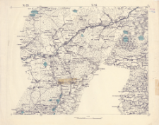
Download allTitle: X - 23, X - 24.
Creator:
Rosja. Armiâ. Glavnyj štab. Voenno-topografičeskij otdel ; Rosja. Armiâ. Glavnyj štab. Litografìâ kartografičeskago zavedenìâ
Date issued/created:
Resource type:
Subtitle:
Novaâ topografičeskaâ karta Zapadnoj Rossii 1:84 000. X - 23, X - 24.
Publisher:
Place of publishing:
Description:
Skala 1:84 000 ; 1 mapa : kolorowa ; 33x43 cm, na arkuszu 39x50 cm ; Datowanie w oparciu o serię map, która była wydawana w latach 1885-1917 ; Południk zerowy Pułkowo ustalony przez katalogującego
Relation:
Novaâ topografičeskaâ karta Zapadnoj Rossii 1:84 000
Detailed Resource Type:
Format:
Resource Identifier:
Source:
CBGiOŚ. IGiPZ PAN, sygn. PTG C.22/16 ; click here to follow the link
Language:
Coverage:
Rights:
Terms of use:
Digitizing institution:
Instytut Geografii i Przestrzennego Zagospodarowania Polskiej Akademii Nauk
Original in:
Projects co-financed by:
Access:
Object collections:
- Digital Repository of Scientific Institutes > Partners' collections > Institute of Geography and Spatial Organization PAS (IGiPZ PAN) > Library
- Digital Repository of Scientific Institutes > Partners' collections > Institute of Geography and Spatial Organization PAS (IGiPZ PAN) > Library > Maps and atlases
- Digital Repository of Scientific Institutes > Partners' collections > Institute of Geography and Spatial Organization PAS (IGiPZ PAN) > Library > Selected collections > Polish Geographical Society Collection
- Digital Repository of Scientific Institutes > Literature > Maps/Atlases
Last modified:
Oct 2, 2020
In our library since:
Dec 19, 2019
Number of object content downloads / hits:
55
All available object's versions:
https://rcin.org.pl/publication/96175
Show description in RDF format:
Show description in RDFa format:
Show description in OAI-PMH format:
| Edition name | Date |
|---|---|
| X - 23, X - 24., [między 1885 i 1917] | Oct 2, 2020 |
Objects Similar
Rosja. Armiâ. Glavnyj štab. Voenno-topografičeskij otdel Rosja. Armiâ. Glavnyj štab. Litografìâ kartografičeskago zavedenìâ
Rosja. Armiâ. Glavnyj štab. Voenno-topografičeskij otdel Rosja. Armiâ. Glavnyj štab. Litografìâ kartografičeskago zavedenìâ
Rosja. Armiâ. Glavnyj štab. Voenno-topografičeskij otdel Rosja. Armiâ. Glavnyj štab. Litografìâ kartografičeskago zavedenìâ
Rosja. Armiâ. Glavnyj štab. Voenno-topografičeskij otdel Rosja. Armiâ. Glavnyj štab. Litografìâ kartografičeskago zavedenìâ
Rosja. Armiâ. Glavnyj štab. Voenno-topografičeskij otdel Rosja. Armiâ. Glavnyj štab. Litografìâ kartografičeskago zavedenìâ
Rosja. Armiâ. Glavnyj štab. Voenno-topografičeskij otdel Rosja. Armiâ. Glavnyj štab. Litografìâ kartografičeskago zavedenìâ
Rosja. Armiâ. Glavnyj štab. Voenno-topografičeskij otdel Rosja. Armiâ. Glavnyj štab. Litografìâ kartografičeskago zavedenìâ
Rosja. Armiâ. Glavnyj štab. Voenno-topografičeskij otdel Rosja. Armiâ. Glavnyj štab. Litografìâ kartografičeskago zavedenìâ


