- O repozytorium
- Kolekcje
- Indeksy
- Historia przeglądania
-
Repozytoria RCIN
-
 INSTYTUT ARCHEOLOGII I ETNOLOGII POLSKIEJ AKADEMII NAUK
-
 INSTYTUT BADAŃ LITERACKICH POLSKIEJ AKADEMII NAUK
-
 INSTYTUT BADAWCZY LEŚNICTWA
-
 INSTYTUT BIOLOGII DOŚWIADCZALNEJ IM. MARCELEGO NENCKIEGO POLSKIEJ AKADEMII NAUK
-
 INSTYTUT BIOLOGII SSAKÓW POLSKIEJ AKADEMII NAUK
-
 INSTYTUT CHEMII FIZYCZNEJ PAN
-
 INSTYTUT CHEMII ORGANICZNEJ PAN
-
 INSTYTUT FILOZOFII I SOCJOLOGII PAN
-
 INSTYTUT GEOGRAFII I PRZESTRZENNEGO ZAGOSPODAROWANIA PAN
-
 INSTYTUT HISTORII im. TADEUSZA MANTEUFFLA POLSKIEJ AKADEMII NAUK
-
 INSTYTUT JĘZYKA POLSKIEGO POLSKIEJ AKADEMII NAUK
-
 INSTYTUT MATEMATYCZNY PAN
-
 INSTYTUT MEDYCYNY DOŚWIADCZALNEJ I KLINICZNEJ IM.MIROSŁAWA MOSSAKOWSKIEGO POLSKIEJ AKADEMII NAUK
-
 INSTYTUT PODSTAWOWYCH PROBLEMÓW TECHNIKI PAN
-
 INSTYTUT SLAWISTYKI PAN
-
 SIEĆ BADAWCZA ŁUKASIEWICZ - INSTYTUT TECHNOLOGII MATERIAŁÓW ELEKTRONICZNYCH
-
 MUZEUM I INSTYTUT ZOOLOGII POLSKIEJ AKADEMII NAUK
-
 INSTYTUT BADAŃ SYSTEMOWYCH PAN
-
 INSTYTUT BOTANIKI IM. WŁADYSŁAWA SZAFERA POLSKIEJ AKADEMII NAUK
-

Obiekt
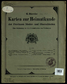
Tytuł: Karten zur heimatkunde der Provinzen Nieder- und Oberschlesien Eine Ergänzung zu den Schulatanten des Verfassers
Twórca:
Diercke, Carl (1842–1913) ; Georg-Westermann-Verlag, Druckerei und Kartographische Anstalt (Brunszwik)
Data wydania/powstania:
Typ zasobu:
Wydawca:
Miejsce wydania:
Opis:
Scales differ ; 1 atlas (VIII p.) : maps col. ; 30 cm ; Date of publication from accession book ; Cited in: Historia Nowożytnej Kartografii Śląska 1800-1939 / Henryk Kot. - Katowice, 1970, poz. 355, p. 180
Szczegółowy typ zasobu:
Format:
File size 12,3 MB ; image/x.djvu
Identyfikator zasobu:
Źródło:
CBGiOŚ. IGiPZ PAN, sygn. B.KS.221 ; kliknij tutaj, żeby przejść
Język:
Prawa:
Zasady wykorzystania:
Digitalizacja:
Institute of Geography and Spatial Organization of the Polish Academy of Sciences
Lokalizacja oryginału:
Dofinansowane ze środków:
Programme Innovative Economy, 2010-2014, Priority Axis 2. R&D infrastructure ; European Union. European Regional Development Fund
Dostęp:
Kolekcje, do których przypisany jest obiekt:
- Repozytorium Cyfrowe Instytutów Naukowych > Kolekcje Partnerów > Instytut Geografii i Przestrzennego Zagospodarowania PAN > Biblioteka Instytutu
- Repozytorium Cyfrowe Instytutów Naukowych > Kolekcje Partnerów > Instytut Geografii i Przestrzennego Zagospodarowania PAN > Biblioteka Instytutu > Mapy i atlasy
- Repozytorium Cyfrowe Instytutów Naukowych > Kolekcje Partnerów > Instytut Geografii i Przestrzennego Zagospodarowania PAN > Biblioteka Instytutu > Wybrane księgozbiory > Księgozbiór Prof. Józefa Staszewskiego
- Repozytorium Cyfrowe Instytutów Naukowych > Piśmiennictwo > Mapy/Atlasy
Data ostatniej modyfikacji:
2 paź 2020
Data dodania obiektu:
9 mar 2012
Liczba pobrań / odtworzeń:
364
Wszystkie dostępne wersje tego obiektu:
https://rcin.org.pl/publication/11659
Wyświetl opis w formacie RDF:
Wyświetl opis w formacie RDFa:
Wyświetl opis w formacie OAI-PMH:
Obiekty Podobne
Kozenn, Blasius (1821–1871) Heiderich, Franz (1863–1923) Schmidt, Wilhelm (1843– ) Mazurek, J. Gustawicz, Bronisław (1852–1916)
Kozenn, Blasius (1821–1871) Gustawicz, Bronisław (1852–1916) Schmidt, Wilhelm (1843– ) Haardt von Hartenthurn, Vinzenz von (1843–1914)
Romer, Eugeniusz (1871–1954) Niemcówna, Stanisława (1891–1961)
Harms, Heinrich (1861–1933) Ostpreussischer Lehrerverein Wiechert, Otto
Sosnowski, Oskar (1880–1939)
Romer, Eugeniusz (1871–1954) Jurczyński, Juliusz (1889–1972) Szumański, Teofil Atlas, Akcyjna Spółka Kartograficzna i Wydawnicza (Lwów)


