Object
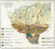
Title: Przeglądowa mapa gleb Wołynia i południowego Polesia : skala 1:800 000 = Übersichtskarte von Volhynischen und Südpolessischen Böden
Subtitle:
Übersichtskarte von Volhynischen und Südpolessischen Böden
Contributor:
Mieczyński, Tadeusz (1888–1947) : Oprac. ; Zakład Reprodukcji Fototechnicznej Stanisława Welanyka (Kraków)
Publisher:
Place of publishing:
Description:
Skala 1:800 000 ; 1 mapa : kolor. ; 34x39 cm, na ark. 39x43 cm ; Tyt. z mapy ; Data wyd. wg Ziemia Wołyńska : miesięcznik poświęcony sprawom krajoznawczym i kulturalnym. - Łuck, 1938. http://bczasopisma.pttk.pl/Ziemia_Wolynska_1938_05.pdf?i19s1s5 ; Mapa wydana w: Wartość użytkowa gleb i gruntów na Wołyniu i na południowym Polesiu / Tadeusz Mieczyński. - Puławy, 1925 ; Tyt. i legenda równol. w jęz. niem. i pol.
Detailed Resource Type:
Format:
Resource Identifier:
Source:
CBGiOŚ. IGiPZ PAN, sygn. PTG D.910 [m.glebowa.1] ; click here to follow the link
Language:
Rights:
Terms of use:
Digitizing institution:
Instytut Geografii i Przestrzennego Zagospodarowania Polskiej Akademii Nauk
Original in:
Projects co-financed by:
Program Operacyjny Innowacyjna Gospodarka, lata 2010-2014, Priorytet 2. Infrastruktura strefy B + R ; Unia Europejska. Europejski Fundusz Rozwoju Regionalnego
Access:
Object collections:
- Digital Repository of Scientific Institutes > Partners' collections > Institute of Geography and Spatial Organization PAS (IGiPZ PAN) > Library
- Digital Repository of Scientific Institutes > Partners' collections > Institute of Geography and Spatial Organization PAS (IGiPZ PAN) > Library > Maps and atlases
- Digital Repository of Scientific Institutes > Partners' collections > Institute of Geography and Spatial Organization PAS (IGiPZ PAN) > Library > Selected collections > Polish Geographical Society Collection
- Digital Repository of Scientific Institutes > Literature > Maps/Atlases
Last modified:
Oct 2, 2020
In our library since:
Mar 14, 2013
Number of object content downloads / hits:
360
All available object's versions:
https://rcin.org.pl/publication/41339
Show description in RDF format:
Show description in RDFa format:
Show description in OAI-PMH format:
Objects Similar
Polska. Główny Urząd Statystyczny. Biuro kartograficzne. Redaktor
Adamov, Nikolaj Pavlovič (1861–1912)

 INSTYTUT ARCHEOLOGII I ETNOLOGII POLSKIEJ AKADEMII NAUK
 INSTYTUT BADAŃ LITERACKICH POLSKIEJ AKADEMII NAUK
 INSTYTUT BADAWCZY LEŚNICTWA
 INSTYTUT BIOLOGII DOŚWIADCZALNEJ IM. MARCELEGO NENCKIEGO POLSKIEJ AKADEMII NAUK
 INSTYTUT BIOLOGII SSAKÓW POLSKIEJ AKADEMII NAUK
 INSTYTUT CHEMII FIZYCZNEJ PAN
 INSTYTUT CHEMII ORGANICZNEJ PAN
 INSTYTUT FILOZOFII I SOCJOLOGII PAN
 INSTYTUT GEOGRAFII I PRZESTRZENNEGO ZAGOSPODAROWANIA PAN
 INSTYTUT HISTORII im. TADEUSZA MANTEUFFLA POLSKIEJ AKADEMII NAUK
 INSTYTUT JĘZYKA POLSKIEGO POLSKIEJ AKADEMII NAUK
 INSTYTUT MATEMATYCZNY PAN
 INSTYTUT MEDYCYNY DOŚWIADCZALNEJ I KLINICZNEJ IM.MIROSŁAWA MOSSAKOWSKIEGO POLSKIEJ AKADEMII NAUK
 INSTYTUT PODSTAWOWYCH PROBLEMÓW TECHNIKI PAN
 INSTYTUT SLAWISTYKI PAN
 SIEĆ BADAWCZA ŁUKASIEWICZ - INSTYTUT TECHNOLOGII MATERIAŁÓW ELEKTRONICZNYCH
 MUZEUM I INSTYTUT ZOOLOGII POLSKIEJ AKADEMII NAUK
 INSTYTUT BADAŃ SYSTEMOWYCH PAN
 INSTYTUT BOTANIKI IM. WŁADYSŁAWA SZAFERA POLSKIEJ AKADEMII NAUK


