- About project
- Collections
- Indexes
- Recently viewed
-
RCIN Repositories
-
 INSTYTUT ARCHEOLOGII I ETNOLOGII POLSKIEJ AKADEMII NAUK
-
 INSTYTUT BADAŃ LITERACKICH POLSKIEJ AKADEMII NAUK
-
 INSTYTUT BADAWCZY LEŚNICTWA
-
 INSTYTUT BIOLOGII DOŚWIADCZALNEJ IM. MARCELEGO NENCKIEGO POLSKIEJ AKADEMII NAUK
-
 INSTYTUT BIOLOGII SSAKÓW POLSKIEJ AKADEMII NAUK
-
 INSTYTUT CHEMII FIZYCZNEJ PAN
-
 INSTYTUT CHEMII ORGANICZNEJ PAN
-
 INSTYTUT FILOZOFII I SOCJOLOGII PAN
-
 INSTYTUT GEOGRAFII I PRZESTRZENNEGO ZAGOSPODAROWANIA PAN
-
 INSTYTUT HISTORII im. TADEUSZA MANTEUFFLA POLSKIEJ AKADEMII NAUK
-
 INSTYTUT JĘZYKA POLSKIEGO POLSKIEJ AKADEMII NAUK
-
 INSTYTUT MATEMATYCZNY PAN
-
 INSTYTUT MEDYCYNY DOŚWIADCZALNEJ I KLINICZNEJ IM.MIROSŁAWA MOSSAKOWSKIEGO POLSKIEJ AKADEMII NAUK
-
 INSTYTUT PODSTAWOWYCH PROBLEMÓW TECHNIKI PAN
-
 INSTYTUT SLAWISTYKI PAN
-
 SIEĆ BADAWCZA ŁUKASIEWICZ - INSTYTUT TECHNOLOGII MATERIAŁÓW ELEKTRONICZNYCH
-
 MUZEUM I INSTYTUT ZOOLOGII POLSKIEJ AKADEMII NAUK
-
 INSTYTUT BADAŃ SYSTEMOWYCH PAN
-
 INSTYTUT BOTANIKI IM. WŁADYSŁAWA SZAFERA POLSKIEJ AKADEMII NAUK
-

Object
Available formats:
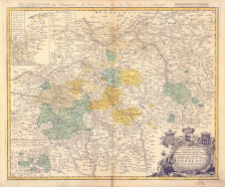
Download allTitle: Les Principautes de Hohenloh, avec les Pays qui y consinent
Subtitle:
Publisher:
Excudentibus Homannianis Heredibus
Place of publishing:
Description:
Scale [approx. 1:170 000] ; 1 map : copperplate, hand color ; 47x57 cm ; Dedication in the cartouche of the map: Serenissimis Principibvs ac Dominis ab Hohenloh, Dynastis in Langenburg, nec non Celsissimis Comitibvs ac Dominis ab Hohenloh et Gleichen, Dynastis in Langenb. et Cranchfeld etc. Dominis meis Clementissimis Principatus Vtr: Hohenloici Tabulam hane Geographicam humillime dicat dedicat Auctor devotissimus Ioh. Carolus Schapuzet ; Prime meridian Ferro ; Ancillary maps: [Grafschaft Gleichen] ; [Aempter Ober- und Nieder-Brunn] ; Title in French, description in Latin
Detailed Resource Type:
Format:
Resource Identifier:
Source:
CBGiOŚ. IGiPZ PAN, call no. B.1645[12] ; click here to follow the link
Language:
Coverage:
Rights:
Terms of use:
Digitizing institution:
Institute of Geography and Spatial Organization of the Polish Academy of Sciences
Original in:
Projects co-financed by:
Access:
Object collections:
- Digital Repository of Scientific Institutes > Partners' collections > Institute of Geography and Spatial Organization PAS (IGiPZ PAN) > Library
- Digital Repository of Scientific Institutes > Partners' collections > Institute of Geography and Spatial Organization PAS (IGiPZ PAN) > Library > Maps and atlases
- Digital Repository of Scientific Institutes > Literature > Maps/Atlases
Last modified:
Mar 25, 2021
In our library since:
Feb 19, 2021
Number of object content downloads / hits:
36
All available object's versions:
https://rcin.org.pl/publication/97876
Show description in RDF format:
Show description in RDFa format:
Show description in OAI-PMH format:
| Edition name | Date |
|---|---|
| Chapuset, Johann Karl., 1748, Les Principautes de Hohenloh, avec les Pays qui y consinent | Mar 25, 2021 |
Objects Similar
Homannsche Erben. Wydawca
Homannsche Erben. Wydawca
Reichenbach, J. C. K. Homannsche Erben. Wydawca
Schmidt, Johann Michael Homannsche Erben. Wydawca
Rizzi-Zannoni, Giovanni Antonio (c. 1736 – 1814) Homannsche Erben. Wydawca
Bronner, Christian Maximilian (1681–1763) Homannsche Erben. Wydawca
Cnopf, Matthaeus Ferdinand (1715–1771) Longolius, Paul Daniel (1704–1779) Homannsche Erben. Wydawca


