- About project
- Collections
- Indexes
- Recently viewed
-
RCIN Repositories
-
 INSTYTUT ARCHEOLOGII I ETNOLOGII POLSKIEJ AKADEMII NAUK
-
 INSTYTUT BADAŃ LITERACKICH POLSKIEJ AKADEMII NAUK
-
 INSTYTUT BADAWCZY LEŚNICTWA
-
 INSTYTUT BIOLOGII DOŚWIADCZALNEJ IM. MARCELEGO NENCKIEGO POLSKIEJ AKADEMII NAUK
-
 INSTYTUT BIOLOGII SSAKÓW POLSKIEJ AKADEMII NAUK
-
 INSTYTUT CHEMII FIZYCZNEJ PAN
-
 INSTYTUT CHEMII ORGANICZNEJ PAN
-
 INSTYTUT FILOZOFII I SOCJOLOGII PAN
-
 INSTYTUT GEOGRAFII I PRZESTRZENNEGO ZAGOSPODAROWANIA PAN
-
 INSTYTUT HISTORII im. TADEUSZA MANTEUFFLA POLSKIEJ AKADEMII NAUK
-
 INSTYTUT JĘZYKA POLSKIEGO POLSKIEJ AKADEMII NAUK
-
 INSTYTUT MATEMATYCZNY PAN
-
 INSTYTUT MEDYCYNY DOŚWIADCZALNEJ I KLINICZNEJ IM.MIROSŁAWA MOSSAKOWSKIEGO POLSKIEJ AKADEMII NAUK
-
 INSTYTUT PODSTAWOWYCH PROBLEMÓW TECHNIKI PAN
-
 INSTYTUT SLAWISTYKI PAN
-
 SIEĆ BADAWCZA ŁUKASIEWICZ - INSTYTUT TECHNOLOGII MATERIAŁÓW ELEKTRONICZNYCH
-
 MUZEUM I INSTYTUT ZOOLOGII POLSKIEJ AKADEMII NAUK
-
 INSTYTUT BADAŃ SYSTEMOWYCH PAN
-
 INSTYTUT BOTANIKI IM. WŁADYSŁAWA SZAFERA POLSKIEJ AKADEMII NAUK
-

Object
Available formats:
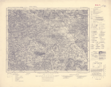
Download allTitle: Karte des Deutschen Reiches 1:100 000, 577. Grunzenhausen
Creator:
Bawaria (Niemcy ; land). Topographisches Bureau. Redaktor ; Wirtembergia (Niemcy). Ministerium des Innern. Hauptvermessungsabteilung XII. Wydawca ; Prusy. Landesaufnahme. Wydawca
Date issued/created:
Resource type:
Subtitle:
Karte des Deutschen Reiches 1:100 000 ; 577
Publisher:
Hauptvermessungsabteilung XII : ; Landesaufnahme
Place of publishing:
Description:
Skala 1:100 000 ; 1 mapa ; 30x38 cm, na arkuszu 40x51 cm ; Na dolnym marginesie: Einzelne Nachträge 1940. Neudruck 1951, Landesaufnahme, Berlin SW 68
Type of object:
Relation:
Karte des Deutschen Reiches 1:100 000
Detailed Resource Type:
Format:
Resource Identifier:
Source:
CBGiOŚ. IGiPZ PAN, sygn. C.187/88 ; 10°20'-E 10°50'/N 49°15'-N 49°00')
Language:
Coverage:
Rights:
Terms of use:
Digitizing institution:
Instytut Geografii i Przestrzennego Zagospodarowania Polskiej Akademii Nauk
Original in:
Projects co-financed by:
Access:
Object collections:
- Digital Repository of Scientific Institutes > Partners' collections > Institute of Geography and Spatial Organization PAS (IGiPZ PAN) > Library
- Digital Repository of Scientific Institutes > Partners' collections > Institute of Geography and Spatial Organization PAS (IGiPZ PAN) > Library > Maps and atlases
- Digital Repository of Scientific Institutes > Literature > Maps/Atlases
Last modified:
Oct 2, 2020
In our library since:
Dec 17, 2019
Number of object content downloads / hits:
59
All available object's versions:
https://rcin.org.pl/publication/96901
Show description in RDF format:
Show description in RDFa format:
Show description in OAI-PMH format:
| Edition name | Date |
|---|---|
| 577. Grunzenhausen, 1951 | Oct 2, 2020 |
Objects Similar
Bawaria (Niemcy ; land). Topographisches Bureau. Redaktor Niemcy. Hauptvermessungsabteilung XIII. Wydawca Prusy. Landesaufnahme. Wydawca
Niemcy. Reichsamt für Landesaufnahme. Wydawca Wirtembergia (Niemcy). Ministerium des Innern. Hauptvermessungsabteilung XII. Redaktor
Württembergisches Statistisches Landesamt. Redaktor Wirtembergia (Niemcy). Ministerium des Innern. Hauptvermessungsabteilung XII. Wydawca Badenia-Wirtemberia (Niemcy ; land). Landesvermessungsamt. Wydawca
Bawaria (Niemcy ; land). Topographisches Bureau. Redaktor
Bawaria (Niemcy ; land). Topographisches Bureau. Redaktor
Bawaria (Niemcy ; land). Topographisches Bureau. Redaktor
Bawaria (Niemcy ; land). Topographisches Bureau. Redaktor
Bawaria (Niemcy ; land). Topographisches Bureau. Redaktor


